

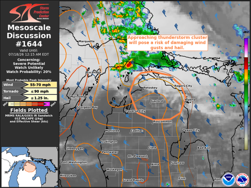
| Mesoscale Discussion 1644 | |
| < Previous MD | |

|
|
   Mesoscale Discussion 1644
   NWS Storm Prediction Center Norman OK
   0851 PM CDT Fri Jul 17 2026

   Areas affected...Northern Lower Michigan

   Concerning...Severe potential...Watch unlikely

   Valid 180151Z - 180415Z

   Probability of Watch Issuance...20 percent

   SUMMARY...An approaching thunderstorm cluster will pose a risk of
   damaging wind gusts as it moves into northern Lower Michigan over
   the next couple of hours.

   DISCUSSION...The latest radar data from KAPX shows a loosely
   organized thunderstorm cluster tracking southeastward from eastern
   Upper MI and northern Lake MI, with additional cells developing
   along the southern and western flanks. Over the next couple of
   hours, this activity should continue tracking southeastward along a
   buoyancy gradient extending into northern Lower MI. Here, the APX
   00Z sounding sampled an elongated hodograph (around 45 kt of
   effective shear) with modest low-level hodograph curvature (210
   m2/s2 effective SRH) and around 800 J/kg MLCAPE. Given the
   established cold pool and continued upscale growth, this downstream
   environment should support the maintenance of this thunderstorm
   cluster into northern Lower MI. The primary concern will be damaging
   wind gusts, though isolated severe hail will also be possible. Given
   the localized nature of the risk, a watch is not expected.

   ..Weinman/Hart.. 07/18/2026

   ...Please see www.spc.noaa.gov for graphic product...

   ATTN...WFO...APX...

   LAT...LON   45658524 45818502 45848462 45758395 45478353 45178337
               44778358 44608394 44588454 44778513 45288544 45658524

   MOST PROBABLE PEAK TORNADO INTENSITY...UP TO 90 MPH
   MOST PROBABLE PEAK WIND GUST...55-70 MPH
   MOST PROBABLE PEAK HAIL SIZE...UP TO 1.25 IN
|
|
|
Top/All Mesoscale Discussions/Forecast Products/Home |
|
Source link