

| Mesoscale Discussion 1635 | |
| < Previous MD | |

|
|
   Mesoscale Discussion 1635
   NWS Storm Prediction Center Norman OK
   0511 PM CDT Thu Jul 16 2026

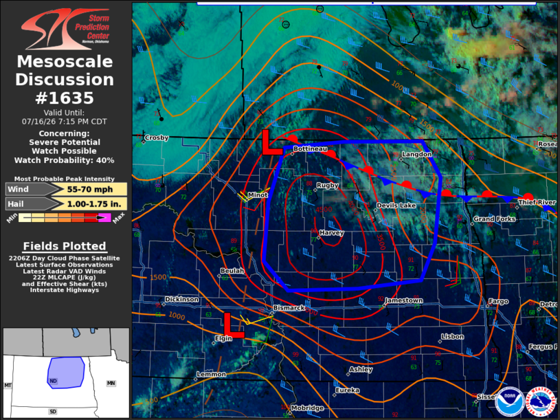
   Areas affected...north-central and northeast North Dakota

   Concerning...Severe potential...Watch possible

   Valid 162211Z - 170015Z

   Probability of Watch Issuance...40 percent

   SUMMARY...The threat for at least isolated occurrences of large hail
   and severe wind gusts is expected to increase this evening.
   Convective trends are being monitored for a possible severe
   thunderstorm watch.

   DISCUSSION...Visible satellite imagery depicts a deepening cumulus
   field across portions of Bottineau and McHenry Counties in the
   vicinity of a subtle meso-low triple point. Latest deterministic and
   time-lagged CAM guidance suggests that storm initiation will become
   increasingly likely by 00Z (7 PM CDT) as the remaining convective
   inhibition is eroded by continued heating and low-level convergence.
   An additional storm or two is possible farther south on a surface
   trough/weak front south of Bismarck.

   In the absence of appreciable large-scale forcing for ascent, it
   remains unclear what the eventual areal coverage of storms will be.
   Nonetheless, latest objective analyses suggest that the local
   environment features moderate to strong instability with MLCAPE as
   high as 3000-3500 J/kg. When coupled with a vertically veering wind
   profile with 30-40 kt of effective bulk shear, the setup appears
   favorable for some organized storm modes, including supercells
   initially with a subsequent transition to a cold-pool driven
   convective system. The primary hazards in that scenario would be
   large hail and severe wind gusts. Forecast storm motions for a
   right-moving supercell suggest that residence time along an existing
   outflow boundary in the area will remain limited, which is expected
   to preclude a more robust tornado threat.

   As mentioned above, eventual storm coverage remains uncertain, which
   will dictate the need for a watch. If it becomes apparent that
   multiple severe storms will develop, a severe thunderstorm watch may
   be considered.

   ..Mead/Hart.. 07/16/2026

   ...Please see www.spc.noaa.gov for graphic product...

   ATTN...WFO...FGF...BIS...

   LAT...LON   48210088 48900059 48979945 48989794 48519760 47689774
               47229800 47129918 47080049 47460094 48210088

   MOST PROBABLE PEAK WIND GUST...55-70 MPH
   MOST PROBABLE PEAK HAIL SIZE...1.00-1.75 IN
|
|
|
Top/All Mesoscale Discussions/Forecast Products/Home |
|
Source link