

| Mesoscale Discussion 1630 | |
| < Previous MD | |

|
|
   Mesoscale Discussion 1630
   NWS Storm Prediction Center Norman OK
   1019 PM CDT Wed Jul 15 2026

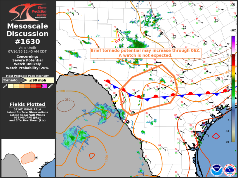
   Areas affected...South-central Texas

   Concerning...Severe potential...Watch unlikely

   Valid 160319Z - 160545Z

   Probability of Watch Issuance...20 percent

   SUMMARY...The potential for a brief tornado or two is expected to
   increase overnight. The brief nature of the threat will likely
   preclude a watch issuance.

   DISCUSSION...Increased forcing for ascent attendant to a vorticity
   lobe shifting east out of Mexico along with strengthening warm
   advection and moisture flux along a nocturnal low-level jet (LLJ) is
   expected to foster an increase in thunderstorm coverage overnight
   across the discussion area. That scenario has already begun as of
   03Z with isolated storms developing from southwest through northwest
   of the San Antonio metro area, including some supercell structures.

   While the primary hazard will be excessive rainfall, a modest
   increase in low-level shear along the LLJ may yield some updraft
   rotation and an attendant brief tornado threat.

   ..Mead/Guyer.. 07/16/2026

   ...Please see www.spc.noaa.gov for graphic product...

   ATTN...WFO...CRP...EWX...

   LAT...LON   28650022 29260035 29729985 30169869 29759822 29239809
               28859839 28679919 28439989 28650022

   MOST PROBABLE PEAK TORNADO INTENSITY...UP TO 90 MPH
|
|
|
Top/All Mesoscale Discussions/Forecast Products/Home |
|
Source link