

| Mesoscale Discussion 1629 | |
| < Previous MD | |

|
|
   Mesoscale Discussion 1629
   NWS Storm Prediction Center Norman OK
   0623 PM CDT Wed Jul 15 2026

   Areas affected...central into southeast lower Michigan

   Concerning...Severe potential...Watch unlikely

   Valid 152323Z - 160130Z

   Probability of Watch Issuance...20 percent

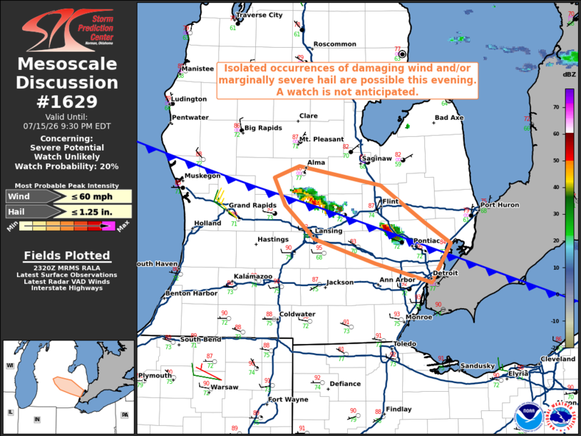
   SUMMARY...Isolated occurrences of damaging wind and/or marginally
   severe hail appear possible with thunderstorms developing across the
   discussion area. A watch is not currently expected.

   DISCUSSION...Thunderstorms have recently developed along a cold
   front from Gratiot and Clinton Counties into Oakland County.
   Although smoke and some high cloudiness are likely reducing diabatic
   warming, latest surface observations indicate temperatures in the
   low 90s south of the front, which coupled with dewpoints in the low
   to mid 70s, is resulting in a moderately to strongly unstable air
   mass with MLCAPE as high as 2500-3000 J/kg, per latest objective
   analysis. However, closer inspection of RAP-based soundings
   indicates the presence of relatively warm mid-level temperatures,
   which are reducing lapse rates through the 700-500 mb layer. That
   coupled with a considerable amount of dry air through that layer and
   the absence of appreciable forcing for ascent, it's quite possible
   that the available parcel buoyancy may be less than what objective
   analysis suggests.

   The presence of 30-40 kt of northwesterly deep-layer shear may
   offset some of the thermodynamic limitations, potentially leading to
   episodic supercell structures with an associated risk for locally
   damaging winds and marginally severe hail. Given the expected areal
   coverage and magnitude of the threat, a watch is not currently
   expected.

   ..Mead/Guyer.. 07/15/2026

   ...Please see www.spc.noaa.gov for graphic product...

   ATTN...WFO...DTX...GRR...

   LAT...LON   42468376 42698453 43018491 43278505 43388473 43208368
               42868312 42668279 42298304 42468376

   MOST PROBABLE PEAK WIND GUST...UP TO 60 MPH
   MOST PROBABLE PEAK HAIL SIZE...UP TO 1.25 IN
|
|
|
Top/All Mesoscale Discussions/Forecast Products/Home |
|
Source link