

| Mesoscale Discussion 1578 | |
| < Previous MD | |

|
|
   Mesoscale Discussion 1578
   NWS Storm Prediction Center Norman OK
   0348 PM CDT Fri Jul 10 2026

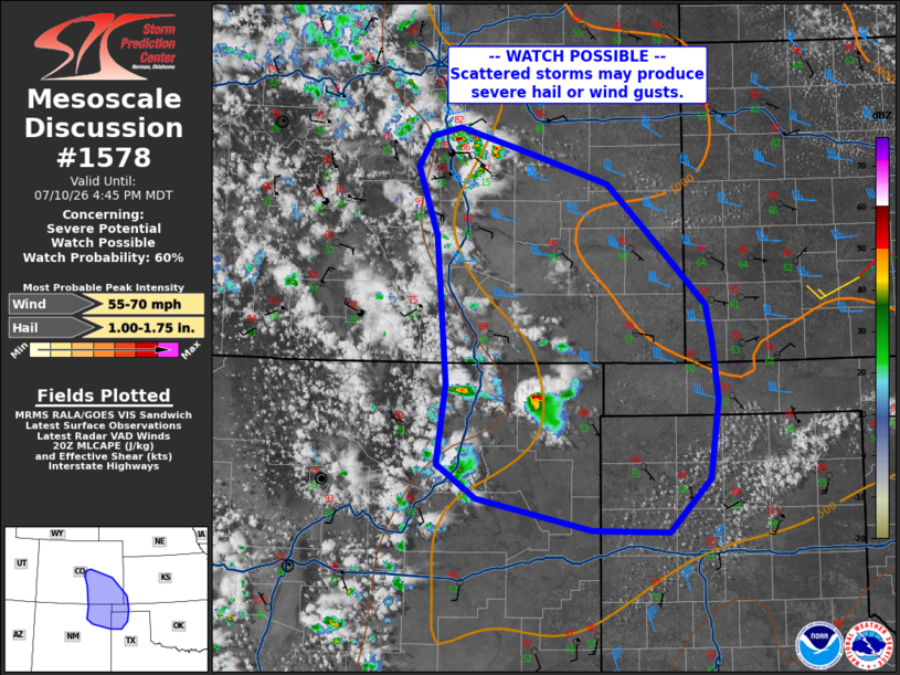
   Areas affected...southeast Colorado and northeast New Mexico into
   the Texas Panhandle

   Concerning...Severe potential...Watch possible

   Valid 102048Z - 102245Z

   Probability of Watch Issuance...60 percent

   SUMMARY...Storms will increase in coverage and spread southeast
   through evening, producing severe gusts or isolated hail.

   DISCUSSION...Strong heating persists from the TX Panhandle into
   eastern CO, while southeast surface winds maintain 50s F dewpoints.
   Modest westerlies aloft combined with the backed low-level winds are
   resulting in 30-35 kt effective shear, with overall steep low to
   midlevel lapse rates. Notably, 300 mb temperatures are relatively
   warm, reducing CAPE somewhat.

   Storms are already forming along the Front Range and into northeast
   NM, and this trend will continue with scattered cells and clusters
   expected through evening. Some cells may briefly produce hail,
   though damaging gusts appear to be the primary threat as boundary
   layer lapse rates are steep. Storms may make it into the OK and TX
   Panhandles this evening, where southerly 850 mb winds of 35 kt will
   be favorable for inflow.

   ..Jewell.. 07/10/2026

   ...Please see www.spc.noaa.gov for graphic product...

   ATTN...WFO...DDC...GLD...AMA...PUB...BOU...ABQ...

   LAT...LON   37920217 37540179 37220172 36640166 35890176 35400224
               35420313 35710449 36040495 36800485 38180497 38840519
               39120503 39210469 38990396 38670294 37920217

   MOST PROBABLE PEAK WIND GUST...55-70 MPH
   MOST PROBABLE PEAK HAIL SIZE...1.00-1.75 IN
|
|
|
Top/All Mesoscale Discussions/Forecast Products/Home |
|
Source link