

| Mesoscale Discussion 1569 | |
| < Previous MD | |

|
|
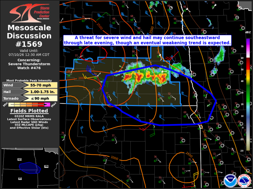
Mesoscale Discussion 1569 NWS Storm Prediction Center Norman OK 1023 PM CDT Thu Jul 09 2026 Areas affected...Southeast ND into northeast SD and extreme west-central MN Concerning...Severe Thunderstorm Watch 476... Valid 100323Z - 100530Z The severe weather threat for Severe Thunderstorm Watch 476 continues. SUMMARY...A threat for severe wind and hail will continue southeastward through late evening, though an eventual weakening trend is expected. DISCUSSION...A persistent cluster of storms with embedded supercell structures is moving southeastward across southeast ND late this evening. A few measured severe gusts and reports of wind damage have recently been noted, while MRMS hail-size estimates continue to occasionally exceed severe criteria. While a favorable combination of buoyancy and deep-layer shear is in place downstream of this cluster, nocturnal cooling and increasing MLCINH is expected to result in a gradual weakening trend by near/after midnight CDT. Given the forward-propagating nature of this cluster, some threat for severe wind and/or hail may eventually move out of WW 476 into parts of northeast SD and extreme west-central MN. Short-term trends will continue to be monitored regarding any need for downstream watch issuance. ..Dean/Thompson.. 07/10/2026 ...Please see www.spc.noaa.gov for graphic product... ATTN...WFO...MPX...FGF...ABR...BIS... LAT...LON 46800035 47119829 46989763 46759686 46279597 46069576 45479613 45389665 45369811 45489891 45749966 45859985 46000027 46410052 46800035 MOST PROBABLE PEAK TORNADO INTENSITY...UP TO 90 MPH MOST PROBABLE PEAK WIND GUST...55-70 MPH MOST PROBABLE PEAK HAIL SIZE...1.00-1.75 IN |
|
|
Top/All Mesoscale Discussions/Forecast Products/Home |
|
Source link