

| Mesoscale Discussion 1568 | |
| < Previous MD | |

|
|
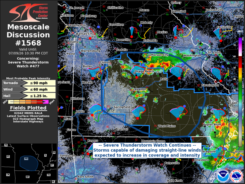
Mesoscale Discussion 1568 NWS Storm Prediction Center Norman OK 0906 PM CDT Thu Jul 09 2026 Areas affected...Central and southeastern Missouri Concerning...Severe Thunderstorm Watch 477... Valid 100206Z - 100330Z The severe weather threat for Severe Thunderstorm Watch 477 continues. SUMMARY...The threat within WW 477 continues until midnight CDT. Severe storms capable of primarily damaging winds, and perhaps a tornado or two, will be possible with storms in and around the watch area. DISCUSSION...Clusters of thunderstorms in central Missouri continue to grow in intensity and spatial coverage this evening. MLCAPE > 2000 J/kg and locally enhanced hodographs in the vicinity of diffuse surface boundary should support continued organization of convection and perhaps transient supercells. These storms will be capable of primarily damaging straight-line winds, but given the curvature of the hodograph/increased helicity, a tornado or two cannot be ruled out. However, disorganized storm-mode and nocturnal stabilization of the boundary layer suggest a tornado threat should be limited. ..Halbert.. 07/10/2026 ...Please see www.spc.noaa.gov for graphic product... ATTN...WFO...PAH...LSX...LZK...SGF...EAX... LAT...LON 38489355 38699292 38699168 38559113 38219064 37869035 37489027 36839051 36519088 36489163 36629233 37009326 37189364 37989369 38489355 MOST PROBABLE PEAK TORNADO INTENSITY...UP TO 90 MPH MOST PROBABLE PEAK WIND GUST...UP TO 60 MPH MOST PROBABLE PEAK HAIL SIZE...UP TO 1.25 IN |
|
|
Top/All Mesoscale Discussions/Forecast Products/Home |
|
Source link