

| Mesoscale Discussion 1564 | |
| < Previous MD | |

|
|
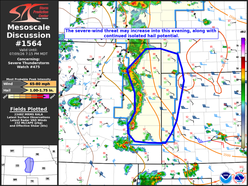
Mesoscale Discussion 1564 NWS Storm Prediction Center Norman OK 0650 PM CDT Thu Jul 09 2026 Areas affected...Eastern CO into western KS and far southwest NE Concerning...Severe Thunderstorm Watch 475... Valid 092350Z - 100115Z The severe weather threat for Severe Thunderstorm Watch 475 continues. SUMMARY...The severe-wind threat may increase into this evening, in addition to a continued isolated hail threat. DISCUSSION...Convection across eastern CO has gradually evolved into more of a linear mode as of 2345 UTC. Steep low-level lapse rates, favorable low-level easterly flow, and increasing moisture/buoyancy downstream of this convection may result in an increasing severe-wind threat into the evening. MLCAPE of near/above 1500 J/kg and moderate deep-layer shear will remain supportive of organized convection, and a swath of 60-80 mph gusts will be possible if a more organized cold pool can evolve with time. The strongest embedded updrafts and cells ahead of or along the periphery of the developing line will also continue to pose a threat of isolated large hail into early evening. ..Dean.. 07/09/2026 ...Please see www.spc.noaa.gov for graphic product... ATTN...WFO...LBF...DDC...GLD...PUB...BOU... LAT...LON 40110353 40490309 40800270 40820207 40630132 40140114 39740106 38420140 38120155 37980164 37690187 37700257 37740315 38000343 38300346 38450333 38720315 38980316 39350318 40110353 MOST PROBABLE PEAK WIND GUST...65-80 MPH MOST PROBABLE PEAK HAIL SIZE...1.00-1.75 IN |
|
|
Top/All Mesoscale Discussions/Forecast Products/Home |
|
Source link