

| Mesoscale Discussion 1556 | |
| < Previous MD | |

|
|
   Mesoscale Discussion 1556
   NWS Storm Prediction Center Norman OK
   0201 PM CDT Thu Jul 09 2026

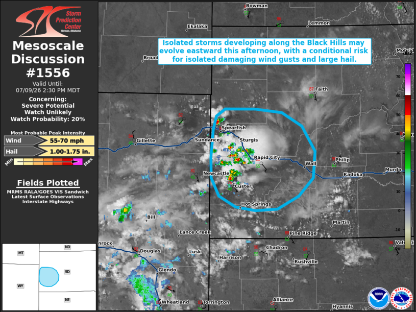
   Areas affected...portions of the Black Hills and southwestern South
   Dakota

   Concerning...Severe potential...Watch unlikely

   Valid 091901Z - 092030Z

   Probability of Watch Issuance...20 percent

   SUMMARY...Isolated thunderstorms may move off the Black Hills in
   southwestern South Dakota and promote an isolated severe threat this
   afternoon. A further increase in strong to severe thunderstorm
   potential is expected late this afternoon and into the evening.

   DISCUSSION...An isolated thunderstorm has recently developed across
   the Black Hills in southwestern South Dakota. While latest objective
   analysis suggests that capping remains in place to the east of the
   Black Hills, modifying the nearby UNR 18z observed sounding for
   current surface observations suggests that inhibition is quickly
   eroding amid continued insolation. This may allow isolated
   convection to evolve eastward off of the Black Hills this afternoon.
   Should this scenario occur, storms would encounter increasing
   instability across central South Dakota, with modest effective shear
   (25-30 kts), well-mixed boundary layer profiles, and steep mid-level
   lapse rates (as sampled by the aforementioned UNR observed sounding)
   promoting a risk for isolated damaging/severe wind gusts and large
   hail. Given that this risk remains conditional on a storm persisting
   eastward off of the Black Hills, watch issuance is uncertain at this
   time. An increase in severe potential and convective coverage is
   then expected later this evening across portions of western South
   Dakota.

   ..Chalmers/Hart.. 07/09/2026

   ...Please see www.spc.noaa.gov for graphic product...

   ATTN...WFO...UNR...

   LAT...LON   43410276 43380317 43430356 43580388 43830402 44130404
               44500399 44700393 44790377 44790318 44750266 44550228
               44200203 43840207 43580234 43410276

   MOST PROBABLE PEAK WIND GUST...55-70 MPH
   MOST PROBABLE PEAK HAIL SIZE...1.00-1.75 IN
|
|
|
Top/All Mesoscale Discussions/Forecast Products/Home |
|
Source link