

| Mesoscale Discussion 1549 | |
| < Previous MD | |

|
|
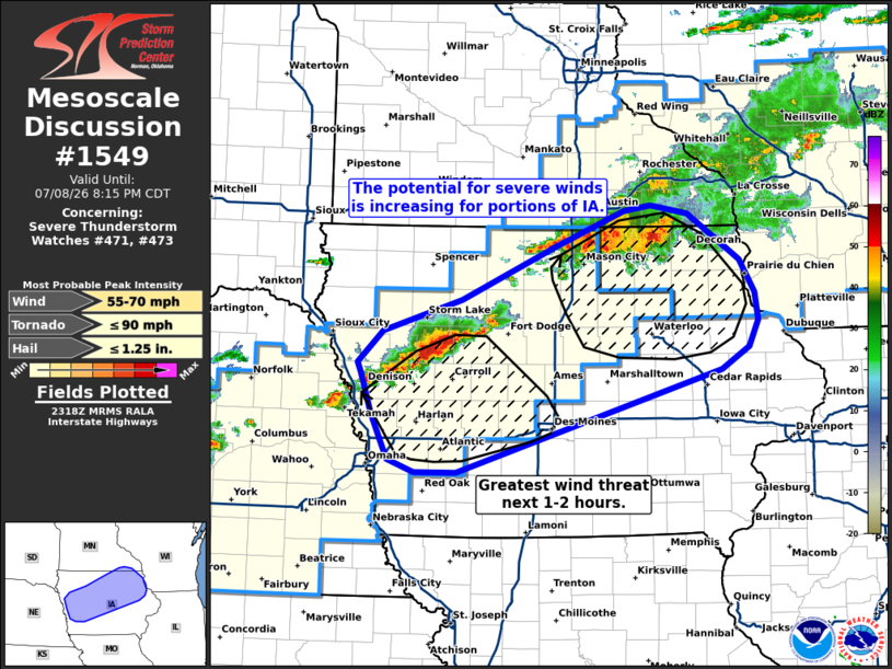
Mesoscale Discussion 1549 NWS Storm Prediction Center Norman OK 0621 PM CDT Wed Jul 08 2026 Areas affected...Western to northeast Iowa Concerning...Severe Thunderstorm Watch 471...473... Valid 082321Z - 090115Z The severe weather threat for Severe Thunderstorm Watch 471, 473 continues. SUMMARY...Corridors of severe wind potential will likely emerge across west-central and northeast Iowa over the next few hours. DISCUSSION...The early stages of deeper cold pool development are noted within a convective cluster in far southeast MN/northeast IA and within an emerging band of convection to northwest of the Des Moines area. This likely signals a transition from semi-discrete supercell/multi-cell storms into a more linear storm mode across both regions. Downstream, temperatures remain in the low to mid 80s with an axis of around 1500-2500 J/kg MLCAPE draped ahead of both clusters, and regional VWPs hint that deep-layer wind shear values are around 30 knots, which appears to be slightly stronger than depicted by latest mesoanalyses. Although low-level lapse rates downstream are not overly favorable for downdraft accelerations, the observed radar trends and downstream environment hint that a couple of corridors of strong to severe winds will likely emerge across western and northeast IA over the next few hours. This scenario is supported by recent HRRR solutions, which suggest peak wind speeds between 60-70 mph will be possible as the clusters/lines become better organized. ..Moore.. 07/08/2026 ...Please see www.spc.noaa.gov for graphic product... ATTN...WFO...DVN...ARX...MPX...DMX...FSD...OAX... LAT...LON 43629187 43179120 42869101 42619097 42369109 42159144 41179481 41179534 41309567 41729588 42099602 42219607 42509575 42819474 43309357 43659268 43709233 43629187 MOST PROBABLE PEAK TORNADO INTENSITY...UP TO 90 MPH MOST PROBABLE PEAK WIND GUST...55-70 MPH MOST PROBABLE PEAK HAIL SIZE...UP TO 1.25 IN |
|
|
Top/All Mesoscale Discussions/Forecast Products/Home |
|
Source link