

| Mesoscale Discussion 1547 | |
| < Previous MD Next MD > | |
|
|
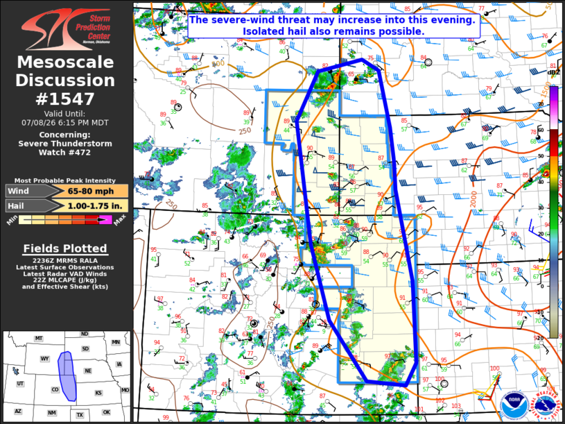
Mesoscale Discussion 1547 NWS Storm Prediction Center Norman OK 0538 PM CDT Wed Jul 08 2026 Areas affected...Parts of eastern WY/CO...the NE Panhandle...southwest SD Concerning...Severe Thunderstorm Watch 472... Valid 082238Z - 090015Z The severe weather threat for Severe Thunderstorm Watch 472 continues. SUMMARY...The severe-wind threat may increase into early evening. Isolated hail also remains possible. DISCUSSION...Scattered thunderstorms are ongoing late this afternoon across parts of the central and northern High Plains. Some recent increase in radar-estimated hail sizes has been noted within WW 472 across southeast WY and northeast CO, and also north of WW 472 into northeast WY. MLCAPE of 1000-1500 J/kg and moderate deep-layer shear will continue to support storm organization and isolated to widely scattered supercells capable of large hail and localized severe gusts through the remainder of the afternoon. With time, increasing storm coverage and related outflow within the relatively well-mixed environment is expected to lead to an increasing severe-wind threat as storms move eastward across northeast CO and the NE Panhandle. While this upscale growth may only become modestly organized, the favorable thermodynamic environment could support one or more swaths of 65-80 mph gusts into this evening. ..Dean.. 07/08/2026 ...Please see www.spc.noaa.gov for graphic product... ATTN...WFO...LBF...UNR...GLD...PUB...BOU...CYS... LAT...LON 37660333 38880429 40400478 42880521 43870465 44120344 43900298 42760268 42060258 41510254 39660213 38030207 37580234 37660333 MOST PROBABLE PEAK WIND GUST...65-80 MPH MOST PROBABLE PEAK HAIL SIZE...1.00-1.75 IN |
|
|
Top/All Mesoscale Discussions/Forecast Products/Home |
|
Source link