

| Mesoscale Discussion 1545 | |
| < Previous MD | |
|
|
   Mesoscale Discussion 1545
   NWS Storm Prediction Center Norman OK
   0312 PM CDT Wed Jul 08 2026

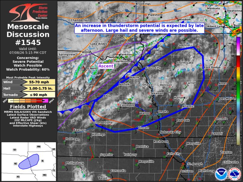
   Areas affected...Parts of eastern Nebraska into central Iowa

   Concerning...Severe potential...Watch possible

   Valid 082012Z - 082215Z

   Probability of Watch Issuance...60 percent

   SUMMARY...Large hail and severe winds will be the primary risk with
   storms that develop later this afternoon. A watch is possible
   depending on convective trends in the next couple of hours.

   DISCUSSION...Water vapor/visible imagery shows a zone of ascent
   overspreading the mid Missouri Valley region. Though mid-level cloud
   cover has had some impact on surface heating south of the surface
   cold front, temperatures still have warmed into the mid 80s to low
   90s F. Based on the observed 18Z OAX sounding, it likely will take
   surface 90+ F surface temperatures to fully remove MLCIN. As the
   cold front slowly sags southward into the evening and the low-level
   jet increases, widely scattered to scattered storm development will
   become more likely. Whether storms can develop earlier than most CAM
   guidance suggests remains a question. There is at least some
   potential for mid-level convection to root near the surface and
   MLCIN erodes. Storms that do form will pose some risk of large hail
   and severe winds given observed steep mid-level lapse rates and
   moderately steep low-level lapse rates. Shear will be somewhat
   marginal, especially with southwest extent. Convective trends will
   continue to be monitored for a possible watch by late afternoon.

   ..Wendt/Hart.. 07/08/2026

   ...Please see www.spc.noaa.gov for graphic product...

   ATTN...WFO...DMX...FSD...OAX...GID...

   LAT...LON   40839666 40729752 40899818 41229848 41589830 42029753
               43049527 43129452 42889417 42249414 41499462 40929632
               40839666

   MOST PROBABLE PEAK TORNADO INTENSITY...UP TO 90 MPH
   MOST PROBABLE PEAK WIND GUST...55-70 MPH
   MOST PROBABLE PEAK HAIL SIZE...1.00-1.75 IN
|
|
|
Top/All Mesoscale Discussions/Forecast Products/Home |
|
Source link