

| Mesoscale Discussion 1508 | |
| < Previous MD | |

|
|
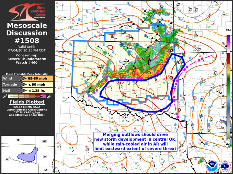
Mesoscale Discussion 1508 NWS Storm Prediction Center Norman OK 0920 PM CDT Sat Jul 04 2026 Areas affected...Southern and eastern Oklahoma Concerning...Severe Thunderstorm Watch 460... Valid 050220Z - 050315Z The severe weather threat for Severe Thunderstorm Watch 460 continues. SUMMARY...The line of storms will continue southeastward with the threat for occasional severe outflow gusts/wind damage into east central/southeast OK, with new storm development possible into central/south central OK with merging outflows. DISCUSSION...Outflow continues to stay a few miles ahead of the primary reflectivity band across central and eastern OK, with the strongest recent gusts in the 50-68 mph range across northeast OK. The eastern extent of the severe threat will be limited over the next few hours by rain-cooled air from earlier storms in AR, but the environment remains favorable for occasional wind damage/severe gusts into east central and southeast OK. Farther west, new storm development is occurring into central OK, especially where a separate outflow from the west interacts with the more east-west oriented outflow boundary moving southward through central OK. There will still be the potential for occasional severe gusts with this western part of the cluster as it progresses into central and south central OK. The more favorable moisture and vertical shear environment is largely confined to OK, with weakening of the storms expected into western AR and by the time the storms reach the Red River. Local extensions of the current watch are still possible, but a new downstream watch appears unnecessary. ..Thompson.. 07/05/2026 ...Please see www.spc.noaa.gov for graphic product... ATTN...WFO...SHV...TSA...OUN... LAT...LON 35629531 36479473 36319420 35999406 35359462 34829481 34409476 34139508 33989556 33999612 34119685 34399759 34629849 34839845 35259807 35349765 35349616 35629531 MOST PROBABLE PEAK TORNADO INTENSITY...UP TO 90 MPH MOST PROBABLE PEAK WIND GUST...65-80 MPH MOST PROBABLE PEAK HAIL SIZE...UP TO 1.25 IN |
|
|
Top/All Mesoscale Discussions/Forecast Products/Home |
|
Source link