

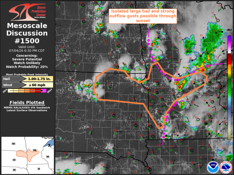
| Mesoscale Discussion 1500 | |
| < Previous MD | |

|
|
   Mesoscale Discussion 1500
   NWS Storm Prediction Center Norman OK
   0507 PM CDT Sat Jul 04 2026

   Areas affected...West central/southwest Minnesota and northeast
   South Dakota

   Concerning...Severe potential...Watch unlikely

   Valid 042207Z - 042330Z

   Probability of Watch Issuance...20 percent

   SUMMARY...Isolated large hail and strong outflow gusts possible
   through sunset, but the overall threat is expected to remain too
   marginal for a watch.

   DISCUSSION...Widely scattered storms are ongoing along a couple of
   outflow boundaries in MN, and along-southwest of a diffuse surface
   trough into northeast SD.  Water vapor imagery shows a weak midlevel
   trough beginning to turn southeastward over northeast SD, which
   should support additional storm development through the evening into
   west central/southwest MN and northeast SD along the weak surface
   boundaries.  Vertical shear is on the lower margins for
   organized/supercell storms in a moderately unstable environment,
   with sufficiently steep low-midlevel lapse rates for isolated large
   hail and strong outflow gusts.  Since storm intensity and
   organization are unlikely to increase from what is observed now, a
   watch is likely not necessary.

   ..Thompson/Gleason.. 07/04/2026

   ...Please see www.spc.noaa.gov for graphic product...

   ATTN...WFO...MPX...FGF...FSD...ABR...BIS...

   LAT...LON   46349597 45989564 45749492 45979371 45779338 45539348
               44899510 44489553 43969572 43919594 44829671 44939841
               44949900 45259927 45779916 46089852 46089845 46019772
               45749737 45609691 45739645 46249628 46349597

   MOST PROBABLE PEAK WIND GUST...UP TO 60 MPH
   MOST PROBABLE PEAK HAIL SIZE...1.00-1.75 IN
|
|
|
Top/All Mesoscale Discussions/Forecast Products/Home |
|
Source link