| Mesoscale Discussion 1476 | |
| < Previous MD | |

|
|
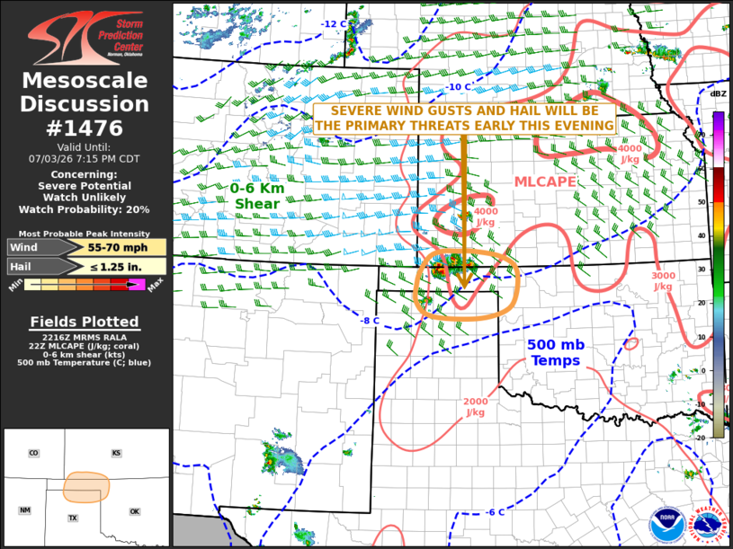
   Mesoscale Discussion 1476
   NWS Storm Prediction Center Norman OK
   0519 PM CDT Fri Jul 03 2026

   Areas affected...Far Southern Kansas...Oklahoma Panhandle...Northern
   Texas Panhandle...Northwest Oklahoma

   Concerning...Severe potential...Watch unlikely

   Valid 032219Z - 040015Z

   Probability of Watch Issuance...20 percent

   SUMMARY...Severe wind gusts and hail will be possible with the
   stronger cells in a cluster over the Oklahoma Panhandle and far
   southern Kansas early this evening. The threat is expected to be too
   isolated for weather watch issuance.

   DISCUSSION...Latest surface analysis shows a 1007 mb low over the
   western Oklahoma Panhandle, with an axis of low-level convergence
   located to the east of the low from the northern Texas Panhandle
   into far southwest Kansas. Along this axis, the RAP has MLCAPE in
   the 3000 to 4000 J/kg range, which will fuel the convection for a
   few more hours. The surface temperature dewpoint spread at Liberal,
   Kansas is 50 degrees F suggesting that the storms are very high
   based. In spite of this, the steep low-level lapse rates could be
   enough for isolated severe wind gusts. The cluster of storms may
   move slowly eastward over the next hour or two, and could eventually
   affect parts of northwest Oklahoma later this evening.

   ..Broyles/Gleason.. 07/03/2026

   ...Please see www.spc.noaa.gov for graphic product...

   ATTN...WFO...OUN...DDC...AMA...

   LAT...LON   37320103 37320138 37210172 36900196 36650204 36290205
               36000167 35940054 36119980 36429954 36959952 37219991
               37310062 37320103

   MOST PROBABLE PEAK WIND GUST...55-70 MPH
   MOST PROBABLE PEAK HAIL SIZE...UP TO 1.25 IN
|
|
|
Top/All Mesoscale Discussions/Forecast Products/Home |
|
Source link