| Mesoscale Discussion 1458 | |
| < Previous MD | |

|
|
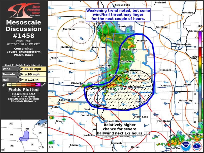
Mesoscale Discussion 1458 NWS Storm Prediction Center Norman OK 0847 PM CDT Thu Jul 02 2026 Areas affected...Southwest Minnesota and adjacent portions of South Dakota and Iowa Concerning...Severe Thunderstorm Watch 443... Valid 030147Z - 030345Z The severe weather threat for Severe Thunderstorm Watch 443 continues. SUMMARY...A weakening trend has been observed over the past 1-2 hours across southwest Minnesota. This trend should continue into the late evening hours, but some wind/hail threat may persist for the short term. DISCUSSION...A gradual weakening trend of an MCS has been observed in GOES IR imagery and MRMS echo tops over the past 60-90 minutes across southwest MN. Additionally, a surging outflow boundary is clearly evident in KFSD reflectivity/velocity data, and the KFSD VWP only sampled around 30-40 knot winds within the lowest few kilometers as the line passed. Further weakening is anticipated for the northern section of the line as it begins to migrate out of the regional buoyancy axis and into a more stable air mass. Farther south, some degree of re-development along the outflow is noted along and north of the I-90 corridor in southwest MN. Here, dewpoints in the mid 70s are supporting a pocket of slightly higher buoyancy and somewhat weaker inhibition, which may allow for further re-development along the outflow boundary. An upstream RAOB from OAX sampled 30-35 knot mid-level winds and similar effective bulk shear values, which suggests that any new convection could see some degree of organization (though this appears improbable based on the undercutting nature of the outflow). Consequently, a relatively higher potential for severe hail and/or wind over the next couple of hours will likely reside across far southwest MN into adjacent portions of SD/IA. Beyond the next few hours, further weakening is expected as the band of storms continues to migrate into a more stable air mass across south-central MN and north-central IA. ..Moore.. 07/03/2026 ...Please see www.spc.noaa.gov for graphic product... ATTN...WFO...MPX...DMX...FSD... LAT...LON 42979672 43029704 43189724 43349735 43529738 43639738 43749701 43749662 43829626 44009606 44299588 44699583 44959580 45079572 45299545 45409505 45369473 45249451 45059432 44739424 44479423 44049423 43709427 43419432 43159459 42979503 42909548 42929616 42979672 MOST PROBABLE PEAK TORNADO INTENSITY...UP TO 90 MPH MOST PROBABLE PEAK WIND GUST...55-70 MPH MOST PROBABLE PEAK HAIL SIZE...UP TO 1.25 IN |
|
|
Top/All Mesoscale Discussions/Forecast Products/Home |
|
Source link