| Mesoscale Discussion 1433 | |
| < Previous MD | |

|
|
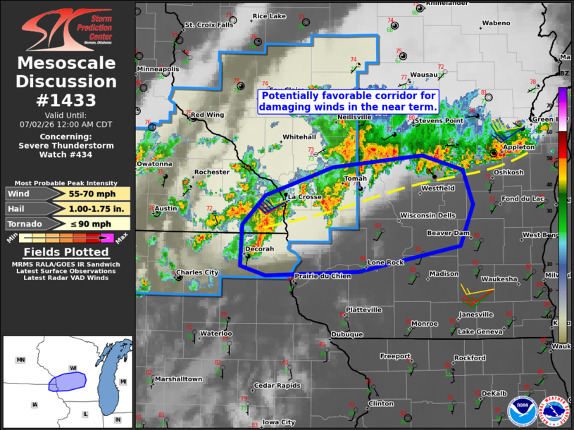
Mesoscale Discussion 1433 NWS Storm Prediction Center Norman OK 1028 PM CDT Wed Jul 01 2026 Areas affected...Far southeast MN...far northeast IA...and western/central WI Concerning...Severe Thunderstorm Watch 434... Valid 020328Z - 020500Z The severe weather threat for Severe Thunderstorm Watch 434 continues. SUMMARY...The potential for damaging wind gusts continues across parts of Severe Thunderstorm Watch 434, especially over parts of western Wisconsin and vicinity in the near term. Convective trends are being monitored for a possible downstream watch. DISCUSSION...The latest radar data from ARX depicts gradual organization/intensification of a small north/south-oriented convective cluster moving eastward across far southeast MN and northeast IA. These storms will continue tracking along/immediately south of a surface boundary/wind shift, generally demarcated by a band of elevated thunderstorms. To the south of the boundary, a warm/moist PBL and around 35 kt of unidirectional 0-3 km shear (per ARX VWP) may support a locally favorable corridor for damaging winds with this cluster of storms and any new development along/south of the boundary with eastward extent. Convective trends are being monitored for a possible downstream watch. ..Weinman.. 07/02/2026 ...Please see www.spc.noaa.gov for graphic product... ATTN...WFO...GRB...MKX...ARX... LAT...LON 43139029 43099149 43189182 43589180 43869150 44129062 44238945 44098892 43768880 43378896 43139029 MOST PROBABLE PEAK TORNADO INTENSITY...UP TO 90 MPH MOST PROBABLE PEAK WIND GUST...55-70 MPH MOST PROBABLE PEAK HAIL SIZE...1.00-1.75 IN |
|
|
Top/All Mesoscale Discussions/Forecast Products/Home |
|
Source link