| Mesoscale Discussion 1394 | |
| < Previous MD | |

|
|
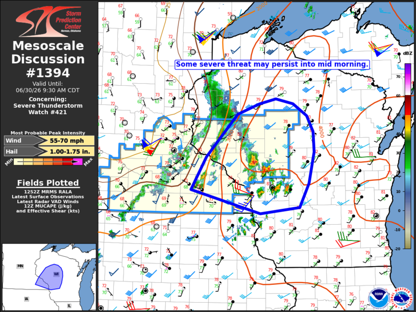
Mesoscale Discussion 1394 NWS Storm Prediction Center Norman OK 0754 AM CDT Tue Jun 30 2026 Areas affected...Parts of southeast MN into western/central WI Concerning...Severe Thunderstorm Watch 421... Valid 301254Z - 301430Z The severe weather threat for Severe Thunderstorm Watch 421 continues. SUMMARY...Some severe threat may continue into mid morning. DISCUSSION...An earlier storm cluster that produced severe wind gusts across southwest MN has mostly dissipated, though a remnant wake low continues to produce gusty winds this morning. Farther east, some uptick in storm coverage and intensity has been noted near/north of La Crosse, WI. Large buoyancy (MUCAPE of 2500-4000 J/kg) and sufficient deep-layer shear will continue to conditionally support organized convection, and generally elevated convection may continue to pose a threat of isolated hail and strong/damaging gusts in the short term. Storm evolution later this morning remains uncertain. A convectively augmented midlevel shortwave trough may help to sustain convection within the favorable environment, and maintain a severe threat. However, the threat may remain isolated until renewed diurnal development occurs later today. As a result, the need for downstream watch issuance in the short term is uncertain, but trends will be monitored for any uptick in storm coverage and organization through the morning. ..Dean/Smith.. 06/30/2026 ...Please see www.spc.noaa.gov for graphic product... ATTN...WFO...GRB...MKX...DLH...ARX...MPX... LAT...LON 43489102 43929277 44529240 45309161 45499104 45589063 45499019 45268983 44978967 44608966 44048980 43609003 43489102 MOST PROBABLE PEAK WIND GUST...55-70 MPH MOST PROBABLE PEAK HAIL SIZE...1.00-1.75 IN |
|
|
Top/All Mesoscale Discussions/Forecast Products/Home |
|
Source link