| Mesoscale Discussion 1343 | |
| < Previous MD Next MD > | |

|
|
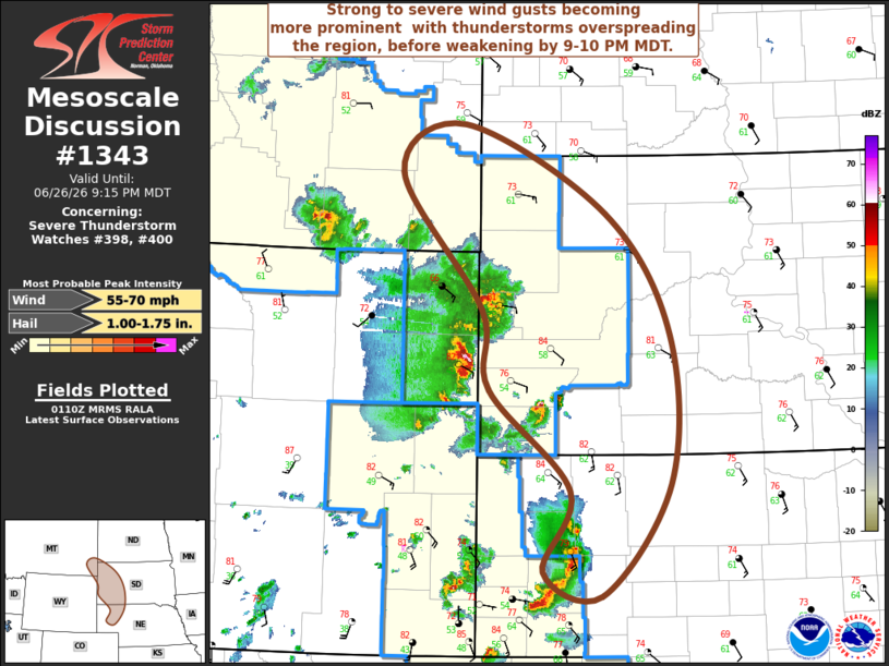
Mesoscale Discussion 1343 NWS Storm Prediction Center Norman OK 0813 PM CDT Fri Jun 26 2026 Areas affected...parts of southeastern Montana...western South Dakota...western Nebraska Concerning...Severe Thunderstorm Watch 398...400... Valid 270113Z - 270315Z The severe weather threat for Severe Thunderstorm Watch 398, 400 continues. SUMMARY...Strong to severe wind gusts may become more prominent with growing thunderstorm clusters overspreading the region, before activity begins to weaken by 9-10 PM MDT. DISCUSSION...Moisture return into the vicinity of the deepening surface troughing to the lee of the Rockies has been modest, but sufficient to support a narrow corridor of CAPE on the order of 1000-2000 J/kg, in the presence of steep lapse rates. Largest potential instability remains focused south-southeast of the Black Hills, with strengthening outflow associated with upscale growing convection likely to progress through much of the instability axis by 03-04Z. Until then, the risk for severe hail will probably persist in stronger cells another hour or two, before more widespread strong to severe gusts becomes more prominent. ..Kerr.. 06/27/2026 ...Please see www.spc.noaa.gov for graphic product... ATTN...WFO...BIS...LBF...UNR...CYS...BYZ... LAT...LON 46240425 45370231 44170144 42700143 41590236 41830316 42640280 43640390 44420400 45770512 46240425 MOST PROBABLE PEAK WIND GUST...55-70 MPH MOST PROBABLE PEAK HAIL SIZE...1.00-1.75 IN |
|
|
Top/All Mesoscale Discussions/Forecast Products/Home |
|
Source link