| Mesoscale Discussion 1307 | |
| < Previous MD | |

|
|
Mesoscale Discussion 1307
NWS Storm Prediction Center Norman OK
0717 AM CDT Thu Jun 25 2026
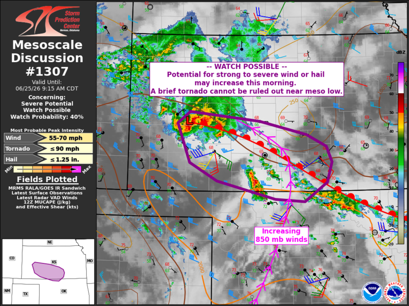
Areas affected...parts of southern Kansas into far northern Oklahoma
Concerning...Severe potential...Watch possible
Valid 251217Z - 251415Z
Probability of Watch Issuance...40 percent
SUMMARY...A storm complex over western Kansas may persist this
morning, resulting in a corridor of damaging wind and marginal hail.
A brief tornado cannot be ruled out near the warm front.
DISCUSSION...A storm complex has developed over west-central KS this
morning near a warm front. Substantial low-level moisture already
exists in this region, and south of the warm front which extends
into south-central KS and northeast KS.
Lift associated with a weak midlevel wave, as well as increasing
southerly boundary-layer winds will maintain a moist and unstable
air mass into the warm frontal zone this morning into the midday
period. Given the size of the existing cluster, further
destabilization, favorable shear and lift along this warm front, a
corridor of wind damage is possible. Transient hail cores in any
leading cells will also be possible, though wind/MCS is most likely.
The latest DDC VWP shows a supercell profile, with over 200 m2/s2
effective SRH supporting transient supercell structures within the
complex.
..Jewell/Gleason.. 06/25/2026
...Please see www.spc.noaa.gov for graphic product...
ATTN...WFO...ICT...OUN...DDC...
LAT...LON 38520055 38359887 38089773 37869726 37569713 37179724
36799778 36849850 37199990 37550055 38310086 38520055
MOST PROBABLE PEAK TORNADO INTENSITY...UP TO 90 MPH
MOST PROBABLE PEAK WIND GUST...55-70 MPH
MOST PROBABLE PEAK HAIL SIZE...UP TO 1.25 IN
|
|
|
Top/All Mesoscale Discussions/Forecast Products/Home |
|
Source link