| Mesoscale Discussion 1278 | |
| < Previous MD | |

|
|
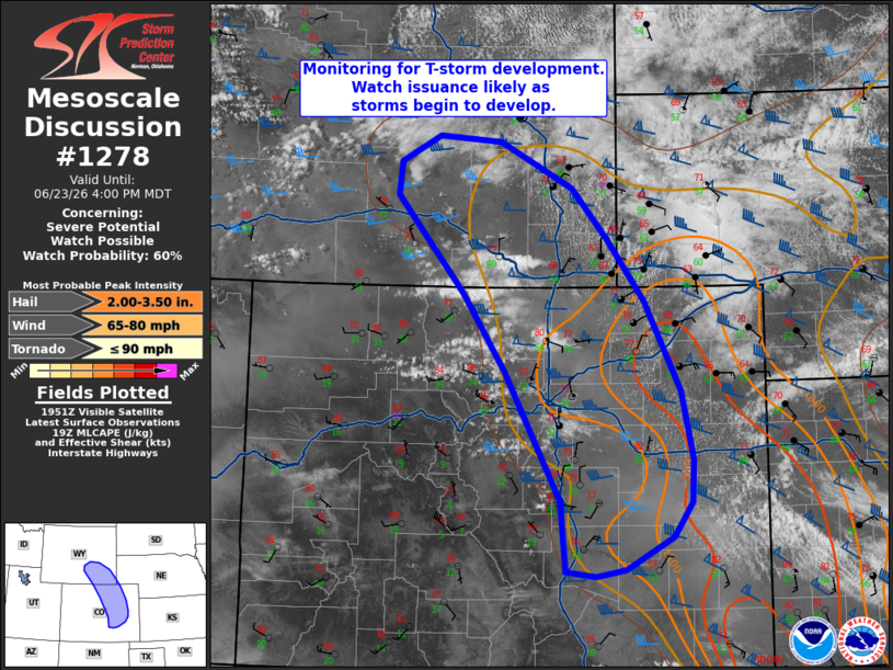
   Mesoscale Discussion 1278
   NWS Storm Prediction Center Norman OK
   0257 PM CDT Tue Jun 23 2026

   Areas affected...northern Colorado into southern Wyoming

   Concerning...Severe potential...Watch possible

   Valid 231957Z - 232200Z

   Probability of Watch Issuance...60 percent

   SUMMARY...Thunderstorm development appears likely in the coming
   hours from northern Colorado into southern Wyoming. Initially
   high-based thunderstorms will intensify as they spread east into the
   lower elevation. Watch issuance will likely be needed as this
   occurs.

   DISCUSSION...Gradual deepening and glaciation of cumulus is noted in
   recent GOES day cloud phase imagery within the higher terrain of
   northern CO and southern WY. This activity is largely being driven
   by a combination of orographic ascent near the base of a layer of
   steep mid-level lapse rates (observed between 7.5 to 8.0 C/km by
   upstream 18 UTC RAOBs). Further deepening and the onset of lightning
   production is expected within the next couple of hours as daytime
   heating continues. The zonal flow regime aloft will advect cells
   eastward into the adjacent High Plains where regionally rich
   low-level moisture (dewpoints in the mid/upper 50s) is in place and
   is supporting a plume of 1000-2000 J/kg MLCAPE. Convection emanating
   off the higher terrain should be able to intensify within this
   thermodynamic environment and mature into primarily discrete
   supercells given around 45-50 knots of effective bulk shear.
   Residual capping and fairly weak forcing for ascent away from the
   terrain casts uncertainty on overall storm coverage, but storms that
   can become sustained over the High Plains will likely pose a threat
   for very large hail as well as severe wind gusts.

   ..Moore/Guyer.. 06/23/2026

   ...Please see www.spc.noaa.gov for graphic product...

   ATTN...WFO...GLD...PUB...BOU...CYS...RIW...

   LAT...LON   38760482 40130559 40930615 41950705 42290701 42570649
               42500565 42030466 41490417 40860368 39920320 39210304
               38750306 38400331 38060395 37990434 38040475 38760482

   MOST PROBABLE PEAK TORNADO INTENSITY...UP TO 90 MPH
   MOST PROBABLE PEAK WIND GUST...65-80 MPH
   MOST PROBABLE PEAK HAIL SIZE...2.00-3.50 IN
|
|
|
Top/All Mesoscale Discussions/Forecast Products/Home |
|
Source link