| Mesoscale Discussion 1277 | |
| < Previous MD | |

|
|
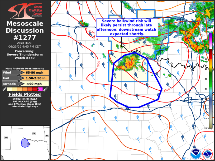
Mesoscale Discussion 1277 NWS Storm Prediction Center Norman OK 0242 PM CDT Tue Jun 23 2026 Areas affected...Northwest Texas Concerning...Severe Thunderstorm Watch 380... Valid 231942Z - 232145Z The severe weather threat for Severe Thunderstorm Watch 380 continues. SUMMARY...A cluster of severe thunderstorms will likely persist through late afternoon and early evening across parts of northwest Texas. Downstream watch issuance will be needed shortly. DISCUSSION...Latest radar imagery from KFDR and KLUB shows continue south/southeastward propagation of a cluster of strong/severe thunderstorms with a history of producing severe wind gusts. Although portions of this cluster are starting to become outflow dominant, additional development is noted on the west/southwest flank of the complex into a very unstable air mass. Given the persistence through late morning/early afternoon, probability seems high that the cluster will continue to pose a severe threat through the diurnal heating maximum when buoyancy will be maximized. Consequently, some severe wind and hail risk should continue downstream into the Rolling Plains of northwest Texas for the next several hours. Downstream watch issuance will be needed to address this concern. ..Moore.. 06/23/2026 ...Please see www.spc.noaa.gov for graphic product... ATTN...WFO...FWD...OUN...SJT...LUB... LAT...LON 33990029 34269987 34369945 34169899 33139838 32779853 32529930 32529971 32700018 32880043 33990029 MOST PROBABLE PEAK TORNADO INTENSITY...UP TO 90 MPH MOST PROBABLE PEAK WIND GUST...65-80 MPH MOST PROBABLE PEAK HAIL SIZE...1.50-2.50 IN |
|
|
Top/All Mesoscale Discussions/Forecast Products/Home |
|
Source link