| Mesoscale Discussion 1264 | |
| < Previous MD | |

|
|
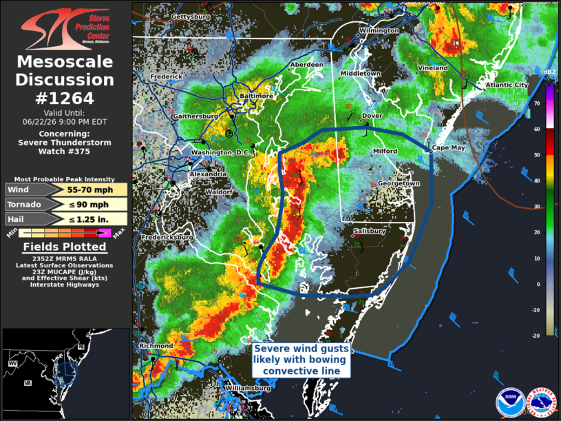
Mesoscale Discussion 1264 NWS Storm Prediction Center Norman OK 0653 PM CDT Mon Jun 22 2026 Areas affected...Portions of the Mid-Atlantic Coastal States Concerning...Severe Thunderstorm Watch 375... Valid 222353Z - 230100Z The severe weather threat for Severe Thunderstorm Watch 375 continues. SUMMARY...A line of thunderstorms moving eastward across the Mid-Atlantic states has developed a pronounced bowing structure and 55-70 MPH measured gusts. This corridor poses the highest threat for damaging winds within WW 375. DISCUSSION...A bowing convective line moving across the Mid-Atlantic has already produced several measured gusts of 55-70 MPH. Over the next hour, this corridor will be the most likely portion of WW 375 to experience severe wind gusts before moving offshore into the Atlantic. Additionally, the environment supports transient leading-edge mesocyclones that will continue to support a risk for a brief tornado or two. ..Halbert.. 06/22/2026 ...Please see www.spc.noaa.gov for graphic product... ATTN...WFO...PHI...AKQ...LWX... LAT...LON 38587490 38177509 37997532 37957543 37947565 37957604 38037642 38127642 38237636 38377626 38557622 38657621 38807624 38927623 39007604 39097587 39107547 39067514 38937489 38587490 MOST PROBABLE PEAK TORNADO INTENSITY...UP TO 90 MPH MOST PROBABLE PEAK WIND GUST...55-70 MPH MOST PROBABLE PEAK HAIL SIZE...UP TO 1.25 IN |
|
|
Top/All Mesoscale Discussions/Forecast Products/Home |
|
Source link