| Mesoscale Discussion 1258 | |
| < Previous MD Next MD > | |

|
|
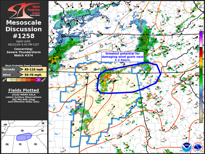
Mesoscale Discussion 1258 NWS Storm Prediction Center Norman OK 0320 PM CDT Mon Jun 22 2026 Areas affected...northern AL and southern Middle TN Concerning...Severe Thunderstorm Watch 374... Valid 222020Z - 222145Z The severe weather threat for Severe Thunderstorm Watch 374 continues. SUMMARY...Strong/damaging wind gust potential may be increasing across northern Alabama into southern Middle Tennessee over the next 1-2 hours. DISCUSSION...A dense cluster of convection over northern AL/southern Middle TN has shown some signs of intensification recently. If this area of convection can consolidate further, damaging wind potential will increase in the short term. This activity is occurring within a favorably shear environment, characterized by 35 kt 0-6 km effective shear and around 200 m2/s2 0-1 km SRH. Radar velocity signatures have also increased both in intensity and with some middle rotation noted. Greater forward propagation of this cluster may be underway and an ensuing risk of severe wind gusts may occur soon. If this evolution unfolds, a downstream watch may be needed. ..Leitman.. 06/22/2026 ...Please see www.spc.noaa.gov for graphic product... ATTN...WFO...MRX...FFC...OHX...BMX...HUN... LAT...LON 35108721 35448505 35338455 34938435 34558461 34308536 34188580 34138696 34138747 34328762 34738758 34908754 35108721 MOST PROBABLE PEAK TORNADO INTENSITY...85-110 MPH MOST PROBABLE PEAK WIND GUST...55-70 MPH |
|
|
Top/All Mesoscale Discussions/Forecast Products/Home |
|
Source link