| Mesoscale Discussion 1249 | |
| < Previous MD | |

|
|
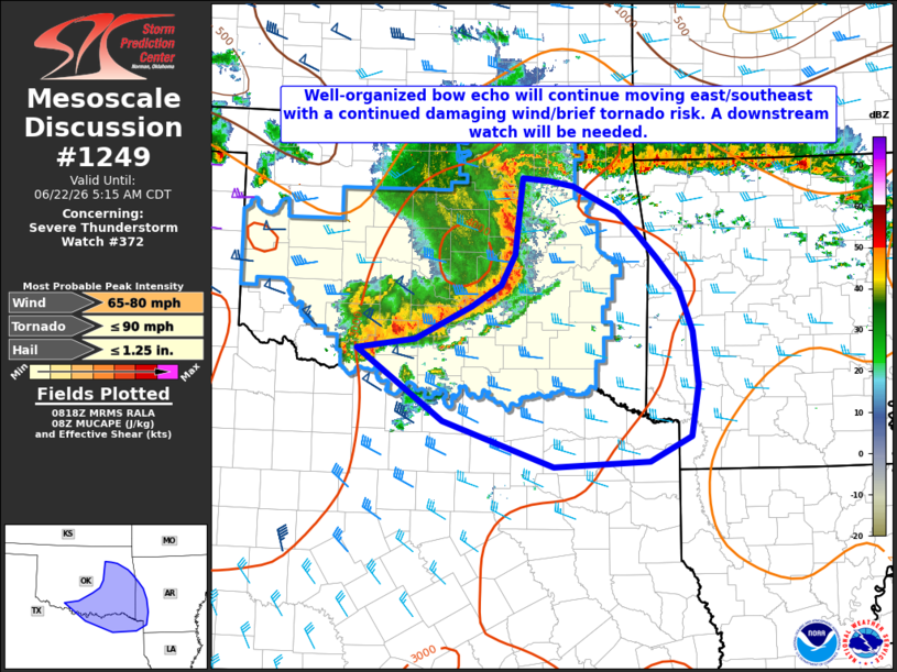
Mesoscale Discussion 1249 NWS Storm Prediction Center Norman OK 0321 AM CDT Mon Jun 22 2026 Areas affected...portions of southern/eastern Oklahoma...western Arkansas...northeast Texas Concerning...Severe Thunderstorm Watch 372... Valid 220821Z - 221015Z The severe weather threat for Severe Thunderstorm Watch 372 continues. SUMMARY...Damaging thunderstorm winds will remain possible as a well-developed bowing complex of severe storms continues to move east/southeast. The severe risk will likely extend beyond WW 372 after 09-10z, and a downstream watch will be needed. DISCUSSION...A long-lived and mature bow echo continues to move east/southeast at around 45 mph across southern/eastern OK as of 0820z. Numerous reports of severe wind gusts have been received during the early morning across OK, with the most recent reports generally in the 60 to 70 mph range. Aided by a well-developed cold pool, evidenced by a 7 mb pressure rise at the Norman mesonet as the system moved through central Oklahoma, severe wind gusts in the 60 to 70 mph range, with isolated higher gusts, will remain likely as the leading edge approaches the southern/eastern edges of WW 372 in the 09-10z time frame. Given the well-organized structure of the MCS and a favorable downstream thermodynamic environment (MUCAPE averaging 3000 J/kg), the severe wind risk is expected to move into western AR/northeast TX, and a downstream Severe Thunderstorm Watch will be coordinated. ..Bunting/Gleason.. 06/22/2026 ...Please see www.spc.noaa.gov for graphic product... ATTN...WFO...LZK...SHV...TSA...FWD...OUN... LAT...LON 34379838 34489760 34849684 35089643 35439625 36069618 36309615 36279580 36219546 35929486 35719461 35399431 35059401 34579384 33979376 33389387 33109443 33059572 33569722 34379838 MOST PROBABLE PEAK TORNADO INTENSITY...UP TO 90 MPH MOST PROBABLE PEAK WIND GUST...65-80 MPH MOST PROBABLE PEAK HAIL SIZE...UP TO 1.25 IN |
|
|
Top/All Mesoscale Discussions/Forecast Products/Home |
|
Source link