| Mesoscale Discussion 1241 | |
| < Previous MD | |

|
|
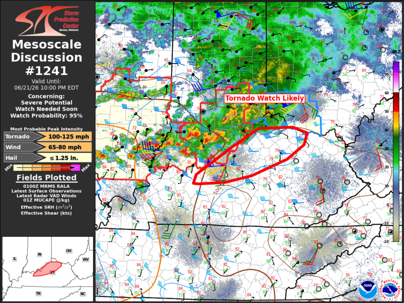
   Mesoscale Discussion 1241
   NWS Storm Prediction Center Norman OK
   0802 PM CDT Sun Jun 21 2026

   Areas affected...portions of northern Kentucky

   Concerning...Severe potential...Watch needed soon

   Valid 220102Z - 220200Z

   Probability of Watch Issuance...95 percent

   SUMMARY...A new tornado watch likely will be needed across portions
   of northern Kentucky.

   DISCUSSION...A tornado threat is likely to develop later this
   evening as a broken line of supercells moves into the region. These
   supercells have a history of confirmed tornadoes. The overall
   environment across northern Kentucky is marginally to moderately
   unstable, with MUCAPE ranging from just under 1000 J/kg to around
   1500 J/kg. Continued low-level theta-e advection to the southeast of
   a MCV across central Indiana should sustain or slightly increase
   instability despite the loss of diurnal heating.

   Additionally, a favorable kinematic environment (Louisville VAD
   showing 0-3 kilometer SRH increasing the last hour to nearly 500
   m2/s2) will remain into the late evening hours. Thus, as the
   upstream supercells move into the region, the threat for tornadoes
   will persist. A new tornado watch will likely be needed within the
   hour.

   ..Marsh/Smith.. 06/22/2026

   ...Please see www.spc.noaa.gov for graphic product...

   ATTN...WFO...JKL...ILN...LMK...

   LAT...LON   37758677 38368578 38788501 38808406 38688366 38418375
               38098424 37748522 37588596 37558670 37568685 37758677

   MOST PROBABLE PEAK TORNADO INTENSITY...100-125 MPH
   MOST PROBABLE PEAK WIND GUST...65-80 MPH
   MOST PROBABLE PEAK HAIL SIZE...UP TO 1.25 IN
|
|
|
Top/All Mesoscale Discussions/Forecast Products/Home |
|
Source link