|
|
| Mesoscale Discussion 1241 | |
| < Previous MD Next MD > | |

|
|
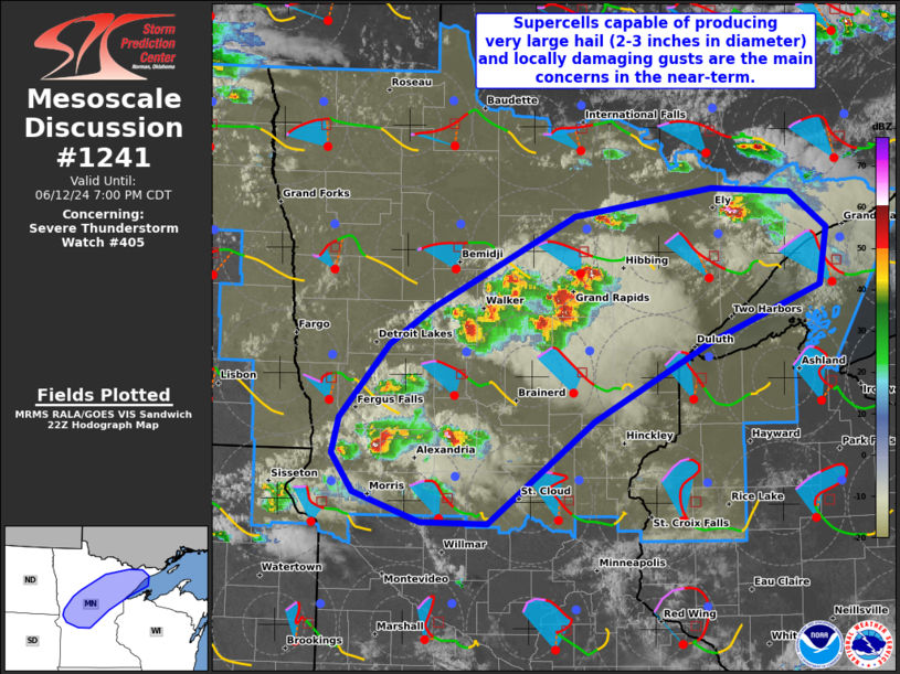
Mesoscale Discussion 1241 NWS Storm Prediction Center Norman OK 0535 PM CDT Wed Jun 12 2024 Areas affected...Portions of northern and central Minnesota Concerning...Severe Thunderstorm Watch 405... Valid 122235Z - 130000Z The severe weather threat for Severe Thunderstorm Watch 405 continues. SUMMARY...Supercells capable of producing very large hail (2-3 inches in diameter) and locally damaging gusts are the main concerns across Severe Thunderstorm Watch 405 for the next hour or so. Tornado and damaging-wind potential may gradually increase with time. DISCUSSION...Latest radar data from KDLH, KMVX, and KABR depict intense, semi-discrete splitting supercells evolving across portions of northern/central MN as of 2230Z. Several 1-1.5-inch hail reports have accompanied this activity. These storms are generally focused along/immediately ahead of a northeast/southwest-oriented surface trough/wind shift, with around 50-60 kt of effective shear oriented perpendicular to this zone of low-level mesoscale ascent. Given a long/mostly straight hodograph (sampled by DLH VWP data), a continuation of splitting semi-discrete supercells capable of very large hail (2-3 inches in diameter) and locally damaging gusts are the main concerns in the near-term. With time, these storms will continue east-southeastward into an area of larger low-level shear/hodograph curvature (see MPX 22Z sounding and VWP), which may favor an increasing tornado threat. In fact, one storm over far northeastern MN appears to be ingesting some of this streamwise vorticity and has recently developed an organized low-level mesocyclone. Convective trends will be monitored for the need for a targeted tornado watch southeast of the ongoing storms. ..Weinman.. 06/12/2024 ...Please see www.spc.noaa.gov for graphic product... ATTN...WFO...DLH...MPX...FGF...ABR... LAT...LON 46199626 46799568 47109516 47839349 48059186 48029095 47729051 47269061 46819190 46189328 45359452 45369530 45599609 45909633 46199626 |
|
|
Top/All Mesoscale Discussions/Forecast Products/Home |
|


