| Mesoscale Discussion 1239 | |
| < Previous MD | |

|
|
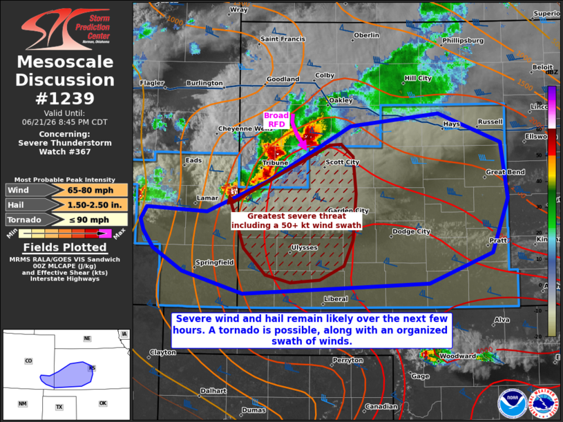
Mesoscale Discussion 1239 NWS Storm Prediction Center Norman OK 0718 PM CDT Sun Jun 21 2026 Areas affected...portions of extreme southeast Colorado into western Kansas Concerning...Severe Thunderstorm Watch 367... Valid 220018Z - 220145Z The severe weather threat for Severe Thunderstorm Watch 367 continues. SUMMARY...Severe wind and hail remain likely with an ongoing line of storms, particularly with embedded supercell structures. A tornado remains possible, and an organized MCS wind swath could develop. DISCUSSION...Supercell structures have gradually merged into an MCS over the past hour. Despite a linear appearance to the broader region of storms, the MCS is flanked to the east by a dominant supercell with a prevalent mesocyclone. A wet rear-flank downdraft associated with this supercell appears to be merging with another embedded cold pool surge to the southwest, which suggests that a smaller scale but organized swath of severe (50+ kt) gusts may be developing. Until then, the stronger storm cores with embedded supercells may support severe hail, and a tornado remains possible with any longer-lasting mesocyclone. The MCS is preceded by 3000-4000 J/kg MLCAPE and 50-60 kts of effective bulk shear, suggesting that the severe threat may last for several more hours. If a prominent bow echo can develop, gusts over 75 mph will also be possible. ..Squitieri.. 06/22/2026 ...Please see www.spc.noaa.gov for graphic product... ATTN...WFO...ICT...DDC...GLD...PUB... LAT...LON 38030357 38000245 38330165 38910055 39049937 38739855 38149845 37569867 37259951 37190097 37160200 37330325 38030357 MOST PROBABLE PEAK TORNADO INTENSITY...UP TO 90 MPH MOST PROBABLE PEAK WIND GUST...65-80 MPH MOST PROBABLE PEAK HAIL SIZE...1.50-2.50 IN |
|
|
Top/All Mesoscale Discussions/Forecast Products/Home |
|
Source link