|
|
| Mesoscale Discussion 1239 | |
| < Previous MD | |

|
|
   Mesoscale Discussion 1239
   NWS Storm Prediction Center Norman OK
   0234 PM CDT Wed Jun 12 2024

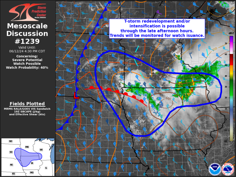
   Areas affected...Portions of the Missouri River Valley into
   southeast Wisconsin

   Concerning...Severe potential...Watch possible

   Valid 121934Z - 122130Z

   Probability of Watch Issuance...40 percent

   SUMMARY...Thunderstorm redevelopment and/or intensification appears
   possible heading into the late afternoon and evening hours across
   eastern South Dakota/Nebraska into southern Minnesota/northern Iowa
   and southwest Wisconsin. Trends will be monitored for the need for
   watch issuance.

   DISCUSSION...Elevated convection continues to develop along and east
   of the MO River Valley within a zone of weak isentropic ascent and
   along convective outflow boundaries. Over the past few hours, this
   activity has largely remained below severe limits with only
   occasional strong updraft pulses based on echo top data and GOES IR
   cloud top temperatures. However, forcing for ascent and deep-layer
   wind shear are both expected to increase in the coming hours as the
   primary synoptic mid-level wave crosses the northern Plains. As this
   occurs, convection may become better organized and intensify,
   especially within the MO River Valley where a buoyant, less
   contaminated warm sector is in place. To the east across MN/IA/WI,
   gradual destabilization continues amid filtered diurnal warming and
   modest moisture return, but storms may outpace the eastward rate of
   destabilization and/or be undercut by outflows. Latest high-res
   guidance also shows a mixed signal regarding the potential for
   re-intensification through late afternoon/early evening, but trends
   will be monitored and watch issuance may be needed if sufficient
   intensification appears likely.

   ..Moore/Goss.. 06/12/2024

   ...Please see www.spc.noaa.gov for graphic product...

   ATTN...WFO...MKX...DVN...ARX...MPX...DMX...FSD...OAX...ABR...

   LAT...LON   44779541 44529478 44379438 44209389 44169325 44149272
               44149205 44139147 44049096 43919064 43789042 43509027
               43239029 42989038 42799069 42709125 42639199 42649255
               42579311 42379354 42049382 41789403 41459459 41329480
               41269510 41269541 41279572 41399604 41519626 42229687
               42699731 43019766 43329790 43749822 44229833 44539828
               44899810 45039787 45169749 45169711 45119673 45049637
               44779541
|
|
|
Top/All Mesoscale Discussions/Forecast Products/Home |
|


