| Mesoscale Discussion 1193 | |
| < Previous MD | |

|
|
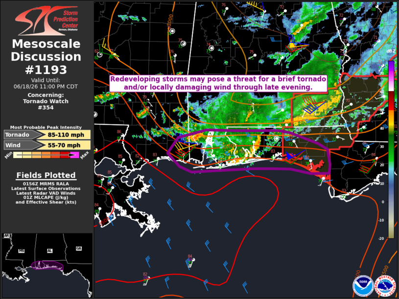
Mesoscale Discussion 1193 NWS Storm Prediction Center Norman OK 0859 PM CDT Thu Jun 18 2026 Areas affected...Far southern MS...south AL...western FL Panhandle Concerning...Tornado Watch 354... Valid 190159Z - 190400Z The severe weather threat for Tornado Watch 354 continues. SUMMARY...Redeveloping storms may pose a threat of a brief tornado and/or locally damaging wind through late evening. DISCUSSION...A small storm cluster with a history of producing a brief tornado is moving across the western FL Panhandle at 0155 UTC this evening. This cluster is moving along the trailing outflow from earlier convection, with relatively enhanced low/midlevel flow still noted on the KEVX VWP. A brief tornado and/or locally damaging wind could still accompany this system through late evening, as it approaches the southwest portion of WW 354. Farther west, storms continue to redevelop near/west of Mobile. This trend may continue into late evening, as moist low-level southwesterly flow continues to impinge on the remnant outflow. While there may be a tendency for the bulk of convection in this area to be slightly elevated, occasional supercell development could be accompanied by a threat for locally damaging wind and a brief tornado, especially where any modest outflow modification can occur. ..Dean.. 06/19/2026 ...Please see www.spc.noaa.gov for graphic product... ATTN...WFO...TAE...MOB...LIX... LAT...LON 30798864 30948803 30938738 30938649 30888623 30678562 30568543 30298537 30128540 30128578 30208622 30228664 30218703 30188783 30158835 30258861 30438880 30508886 30798864 MOST PROBABLE PEAK TORNADO INTENSITY...85-110 MPH MOST PROBABLE PEAK WIND GUST...55-70 MPH |
|
|
Top/All Mesoscale Discussions/Forecast Products/Home |
|
Source link