| Mesoscale Discussion 1185 | |
| < Previous MD | |

|
|
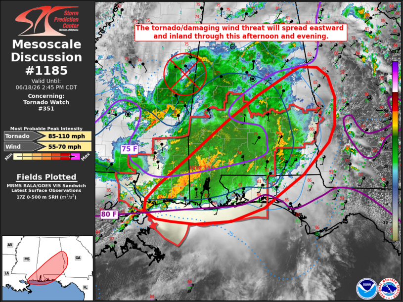
Mesoscale Discussion 1185 NWS Storm Prediction Center Norman OK 1246 PM CDT Thu Jun 18 2026 Areas affected...portions of the central Gulf Coast and Southeast Concerning...Tornado Watch 351... Valid 181746Z - 181945Z The severe weather threat for Tornado Watch 351 continues. SUMMARY...The threat for tornadoes and damaging wind gusts is expected to shift eastward and farther inland with time this afternoon/evening. DISCUSSION...Earlier embedded supercells across southeastern Louisiana/southern Mississippi have congealed into a convective line that has begun to surge more eastward and is now entering southwestern Alabama. Latest radar data from KMOB has sampled up to 60-70+ kt inbound velocities at 1-1.5 kft AGL over the past 30 minutes. This activity is occurring immediately downstream of subtle surface meso-low analyzed northeast of New Orleans and along the southern flank of the convectively-reinforced, remnant mid-level vortex of Tropical Storm Arthur. Expectation is for this convective line to progress eastward and eventually inland along a surface thermal/buoyancy gradient and in conjunction with an eastward shift of the 850 mb jet axis. Rich tropical moisture amid a warm, low-level air mass and modestly enhanced effective shear along the southern periphery of the mid-level vortex will continue to favor maintenance of this convective line along with the potential for damaging wind gusts. Curved low-level hodographs and 0-500 m SRH in excess of 100 m2/s2 will also promote a continued threat for tornadoes, both with this activity and any additional development preceding this convective line. Downstream watch extensions and eventually a new Tornado Watch will likely be needed to cover these threats. ..Chalmers/Hart.. 06/18/2026 ...Please see www.spc.noaa.gov for graphic product... ATTN...WFO...FFC...TAE...BMX...MOB...LIX... LAT...LON 30168957 30428955 30748924 31398845 32198748 32798663 33298578 33448550 33418505 33218476 32738457 32108460 31728475 31008543 30568605 30268646 29968731 29898825 29938889 29998927 30168957 MOST PROBABLE PEAK TORNADO INTENSITY...85-110 MPH MOST PROBABLE PEAK WIND GUST...55-70 MPH |
|
|
Top/All Mesoscale Discussions/Forecast Products/Home |
|
Source link