| Mesoscale Discussion 1183 | |
| < Previous MD | |

|
|
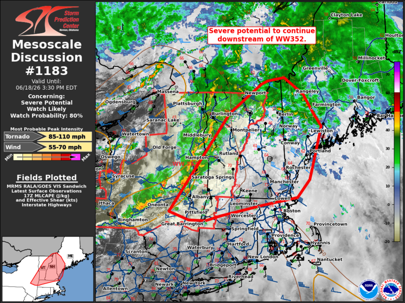
Mesoscale Discussion 1183 NWS Storm Prediction Center Norman OK 1225 PM CDT Thu Jun 18 2026 Areas affected...portions of the Northeast Concerning...Severe potential...Watch likely Valid 181725Z - 181930Z Probability of Watch Issuance...80 percent SUMMARY...Severe potential to continue downstream of WW352. DISCUSSION...A line of low topped convection continues across portions of New York and Vermont, producing reports of wind damage across portions of New York state. This will continue to shift north and eastward into portions of New Hampshire in the next few hours. Strong low to mid-level flow around 50-60 kts, as observed by VAD profiles at CXX and ENX, continues across the region This will continue to support potential for damaging winds and perhaps tornadoes as this line continues downstream. A watch will likely be needed soon. ..Thornton/Hart.. 06/18/2026 ...Please see www.spc.noaa.gov for graphic product... ATTN...WFO...GYX...BOX...BTV...ALY... LAT...LON 45267147 45347096 44967039 44587011 44276985 43697004 43117022 42727059 42557161 42327286 42217332 42217381 42407440 44567263 45207165 45267147 MOST PROBABLE PEAK TORNADO INTENSITY...85-110 MPH MOST PROBABLE PEAK WIND GUST...55-70 MPH |
|
|
Top/All Mesoscale Discussions/Forecast Products/Home |
|
Source link