| Mesoscale Discussion 1171 | |
| < Previous MD | |

|
|
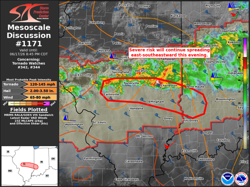
Mesoscale Discussion 1171 NWS Storm Prediction Center Norman OK 0650 PM CDT Wed Jun 17 2026 Areas affected...Parts of south-central Illinois into southwest Indiana Concerning...Tornado Watch 342...344... Valid 172350Z - 180145Z The severe weather threat for Tornado Watch 342, 344 continues. SUMMARY...Large hail, damaging winds, and the potential for a few tornadoes will continue spreading east-southeastward this evening -- within Tornado Watches 342/344. DISCUSSION...A couple supercells are tracking east-southeastward along the southern flank of a larger convective cluster in east-central/southeast IL -- with additional development/intensification farther west in south-central IL. Despite the presence of very strong low/deep-layer flow/shear sampled by the IND VWP (60 kt low-level jet and 650-700 m2/s2 0-1 km SRH), these storms are tracking through a corridor of convectively processed air from earlier storms. However, the strong low-level mass response accompanying an approaching midlevel wave may support additional boundary-layer recovery toward the inflow of these storms during the next few hours. If this can occur, the robust low-level shear/streamwise vorticity will support a few tornadoes (some of which could be strong-intense) with any longer-lived supercells. Very large hail and severe wind gusts (75+ mph) will also be possible with these storms as they continue east-southeastward. ..Weinman.. 06/17/2026 ...Please see www.spc.noaa.gov for graphic product... ATTN...WFO...IND...ILX...LSX... LAT...LON 39128678 38888686 38788721 38928769 39158879 39188973 39368996 39648986 39718954 39718833 39598770 39458719 39338688 39128678 MOST PROBABLE PEAK TORNADO INTENSITY...120-145 MPH MOST PROBABLE PEAK WIND GUST...65-80 MPH MOST PROBABLE PEAK HAIL SIZE...2.00-3.50 IN |
|
|
Top/All Mesoscale Discussions/Forecast Products/Home |
|
Source link