| Mesoscale Discussion 1167 | |
| < Previous MD | |

|
|
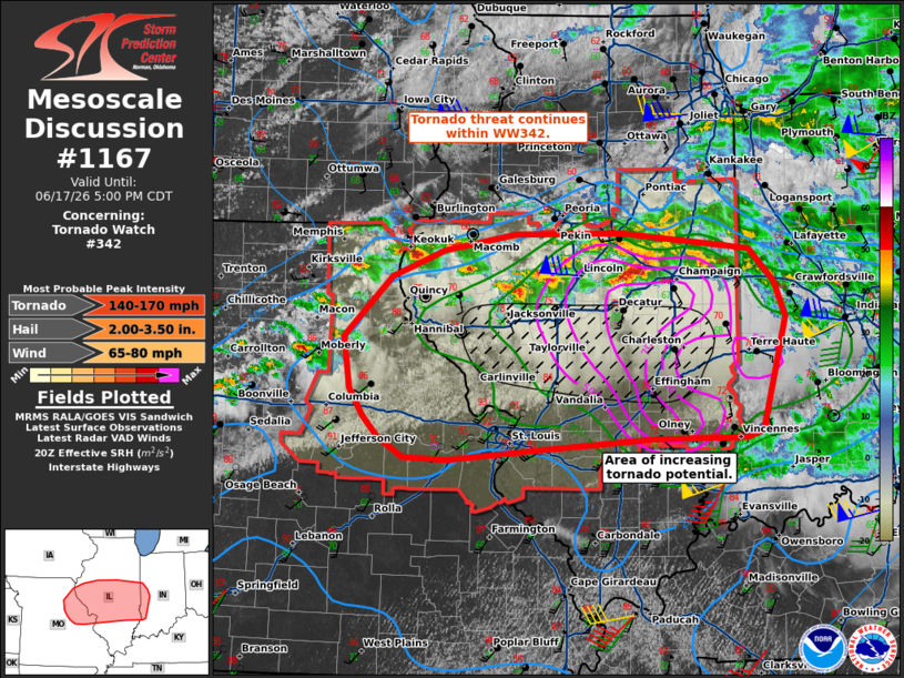
Mesoscale Discussion 1167 NWS Storm Prediction Center Norman OK 0400 PM CDT Wed Jun 17 2026 Areas affected...eastern Missouri...central Illinois...western Indiana Concerning...Tornado Watch 342... Valid 172100Z - 172200Z The severe weather threat for Tornado Watch 342 continues. SUMMARY...Tornado threat continues within WW342. A corridor of increasing tornado potential may emerge across central Illinois during the next couple of hours. DISCUSSION...Air mass recovery is ongoing across central Illinois in the wake of morning convection south of a boundary of strong differential heating. Dew points in the upper 60s to 70s are shifting northward back into central Illinois with temperatures warming in the 80s. Pressure falls are maximized across this region, with strong low-level southerly flow with the strong mass response. North of the boundary, elevated supercell structures have developed. Within this region STP is approaching 3-5 with effective SRH around 700 m2/s2 in the 20z RAOB from ILX. Should a supercell be able to become surface based tornado potential will rapidly increase. Additional watches will need to extend downstream into portions of central/southern Indiana in the next hour. ..Thornton.. 06/17/2026 ...Please see www.spc.noaa.gov for graphic product... ATTN...WFO...IND...LOT...ILX...LSX...DVN... LAT...LON 39589214 40129157 40369097 40519013 40528888 40388739 40078709 39768696 39278709 38738725 38678744 38658852 38578977 38479092 38499143 38669172 38869191 39119207 39589214 MOST PROBABLE PEAK TORNADO INTENSITY...140-170 MPH MOST PROBABLE PEAK WIND GUST...65-80 MPH MOST PROBABLE PEAK HAIL SIZE...2.00-3.50 IN |
|
|
Top/All Mesoscale Discussions/Forecast Products/Home |
|
Source link