| Mesoscale Discussion 1125 | |
| < Previous MD | |

|
|
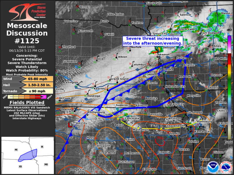
   Mesoscale Discussion 1125
   NWS Storm Prediction Center Norman OK
   0317 PM CDT Sat Jun 13 2026

   Areas affected...southeastern Nebraska...southwestern
   Iowa...northern Missouri

   Concerning...Severe potential...Severe Thunderstorm Watch likely

   Valid 132017Z - 132215Z

   Probability of Watch Issuance...80 percent

   SUMMARY...Thunderstorm activity to increase along the southward
   moving cold front. Initial supercells will be capable of large hail
   and damaging wind.

   DISCUSSION...Thunderstorm activity will increase along the cold
   front this afternoon/evening spreading eastward through time.
   Surface objective analysis is likely underestimating the progression
   northward of better instability in the wake of the morning
   convection. 18z soundings from TOP and DVN suggest MLCAPE is
   spreading northward faster than advertised. Cumulus development is
   increasing near the intersection of a diffuse remnant outflow
   boundary to the south with the cold front further north. Development
   of storms is likely in this region and along the front through the
   evening.

   Given strong deep layer shear profiles (around 40-50 kts), initial
   development will likely be supercellular posing a risk for large
   hail and damaging wind. Through time as the front shifts south and
   east, tendency will be for upscale growth and a shift to more of a
   damaging wind threat. A watch will likely be needed to cover this
   potential.

   ..Thornton/Mosier.. 06/13/2026

   ...Please see www.spc.noaa.gov for graphic product...

   ATTN...WFO...DMX...EAX...OAX...TOP...GID...

   LAT...LON   39969768 39689829 39679851 39729881 39859882 40619831
               41169688 41549569 41709491 41409489 40489505 40059620
               39969768

   MOST PROBABLE PEAK TORNADO INTENSITY...UP TO 90 MPH
   MOST PROBABLE PEAK WIND GUST...65-80 MPH
   MOST PROBABLE PEAK HAIL SIZE...1.50-2.50 IN
|
|
|
Top/All Mesoscale Discussions/Forecast Products/Home |
|
Source link