| Mesoscale Discussion 1109 | |
| < Previous MD | |

|
|
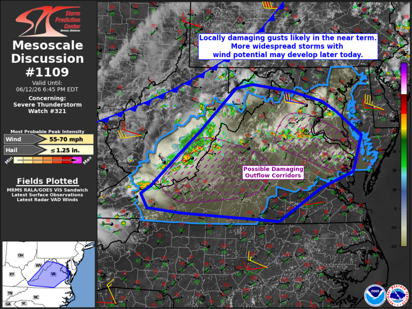
Mesoscale Discussion 1109 NWS Storm Prediction Center Norman OK 0348 PM CDT Fri Jun 12 2026 Areas affected...West Virginia...Virginia...Maryland Concerning...Severe Thunderstorm Watch 321... Valid 122048Z - 122245Z The severe weather threat for Severe Thunderstorm Watch 321 continues. SUMMARY...Storms producing locally damaging gusts may increase in coverage over the next several hours with continued wind potential over much of Virginia and parts of Maryland. DISCUSSION...Two primary areas of thunderstorms have developed this afternoon. One is over northern VA within the surface trough, and another extends from southeast WV into northeast TN related to the residual pre-frontal outflow boundary. Substantial moisture and instability have developed into the region with daytime heating. Not only are low-level lapse rates steep, but GPS PWAT sensors over northern VA have shown a gradual increase in moisture as well. The RLX 18Z sounding as well as LWX and RLX VWPs show mean midlevel westerlies of 20-30 kt, which supports southeastward-moving clusters of storms. The warm and uncapped air mass along with ample PWAT and favorable surface lapse rates will support corridors of strong to severe gusts through early evening. ..Jewell.. 06/12/2026 ...Please see www.spc.noaa.gov for graphic product... ATTN...WFO...AKQ...LWX...RNK...PBZ...RLX... LAT...LON 37587626 37267708 36587816 36758066 36838152 37138169 37308142 37828085 38428019 39297928 39387884 39237785 39037703 38817668 38337603 37587626 MOST PROBABLE PEAK WIND GUST...55-70 MPH MOST PROBABLE PEAK HAIL SIZE...UP TO 1.25 IN |
|
|
Top/All Mesoscale Discussions/Forecast Products/Home |
|
Source link