| Mesoscale Discussion 1108 | |
| < Previous MD | |

|
|
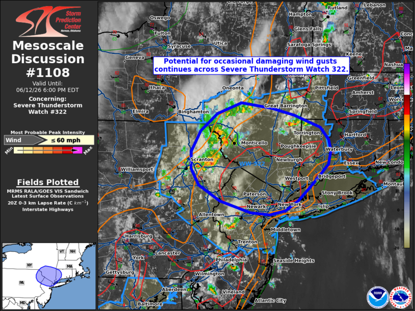
Mesoscale Discussion 1108 NWS Storm Prediction Center Norman OK 0333 PM CDT Fri Jun 12 2026 Areas affected...portions of the Mid-Atlantic into southern New England Concerning...Severe Thunderstorm Watch 322... Valid 122033Z - 122200Z The severe weather threat for Severe Thunderstorm Watch 322 continues. SUMMARY...Isolated damaging wind gusts will remain possible for another couple of hours across Severe Thunderstorm Watch 322. DISCUSSION...Widely scattered thunderstorms are ongoing across portions of northeastern Pennsylvania into southeastern New York, with a dominant storm mode of multicell clusters. One of these clusters recently produced two reports of wind damage in Susquehanna County, PA. Latest objective analysis suggests that available buoyancy has increased to around 2000 J/kg MLCAPE with low-level lapse rates steepening to 7.5-8.0 C/km amid continued afternoon heating. Coupled with 25-30 kts of westerly mid-level flow sampled by the DIX/OKX VWPs, this will continue to support a risk for occasional damaging wind gusts with the ongoing multicell clusters. Convective intensity is then expected to gradually wane later this evening owing to nocturnal low-level cooling/stabilization. ..Chalmers.. 06/12/2026 ...Please see www.spc.noaa.gov for graphic product... ATTN...WFO...BOX...OKX...ALY...PHI...BGM... LAT...LON 41927313 41747297 41597293 41387298 41117328 40867356 40727381 40667410 40687447 40867507 41097547 41337563 41587563 41877544 42137513 42297465 42207407 42117363 41927313 MOST PROBABLE PEAK WIND GUST...UP TO 60 MPH |
|
|
Top/All Mesoscale Discussions/Forecast Products/Home |
|
Source link