|
|
| Mesoscale Discussion 1108 | |
| < Previous MD Next MD > | |

|
|
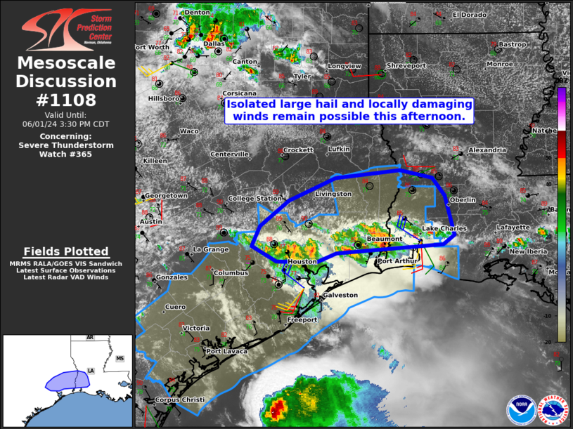
Mesoscale Discussion 1108 NWS Storm Prediction Center Norman OK 0132 PM CDT Sat Jun 01 2024 Areas affected...Portions of southeast Texas and far southwest Louisiana Concerning...Severe Thunderstorm Watch 365... Valid 011832Z - 012030Z The severe weather threat for Severe Thunderstorm Watch 365 continues. SUMMARY...Isolated large hail and locally damaging winds remain possible across portions of southeast Texas and far southwest Louisiana this afternoon. DISCUSSION...Latest radar data from KHGX/KLCH shows loosely organized clusters of convection (with weak embedded rotation) spreading slowly northward along a related outflow boundary across southeast TX and far southwest LA this afternoon. Ahead/north of the outflow, strong heating/destabilization of a very moist boundary layer (middle/upper 70s dewpoints) should support embedded strong updrafts, despite a somewhat anafrontal evolution of the convection. Additionally, VWP depicts around 30-40 kt of 0-6 km shear, and this may increase to around 50 kt as a subtle midlevel speed max (associated with remnant MCV to the northwest) continues east-southeastward. As a result, loosely organized clusters of storms (with transient/embedded supercell structures) will be capable of producing locally damaging winds (60-70 mph) and isolated large hail (1.0-1.75 inches) through the afternoon. ..Weinman.. 06/01/2024 ...Please see www.spc.noaa.gov for graphic product... ATTN...WFO...LCH...HGX... LAT...LON 30079284 29959455 29829488 29839551 30049591 30329579 30679532 30999458 31109354 30999302 30759281 30209266 30079284 |
|
|
Top/All Mesoscale Discussions/Forecast Products/Home |
|


