| Mesoscale Discussion 1095 | |
| < Previous MD | |

|
|
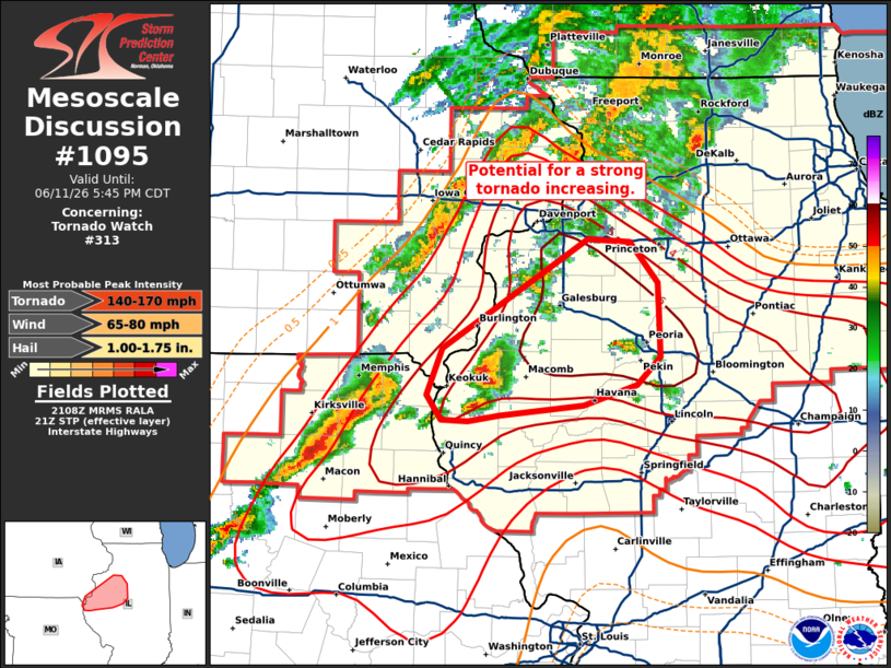
Mesoscale Discussion 1095 NWS Storm Prediction Center Norman OK 0411 PM CDT Thu Jun 11 2026 Areas affected...Western Illinois Concerning...Tornado Watch 313... Valid 112111Z - 112245Z The severe weather threat for Tornado Watch 313 continues. SUMMARY...The tornado potential appears to be increasing across western Illinois. DISCUSSION...Radar imagery out of KILX depicts a strengthening supercell with an organizing mid-level mesocyclone near Carthage, IL. Live web streams depict a strengthening low-level mesocylone as well, suggesting the potential for tornadogenesis is increasing. This cell is drifting northeastward within a warm advection regime where low-level SRH has been increasing per the KILX VWP (0-1 km SRH has recently increased to 200 m2/s2). Per latest RAP mesoanalysis estimates, downstream STP values are also increasing to 6-7. The potential for destructive storm interactions appears limited for the short term (next hour or so), suggesting that the potential for a long-track supercell is increasing with an attendant threat or one or more tornadoes, including possible a strong/intense tornado. ..Moore.. 06/11/2026 ...Please see www.spc.noaa.gov for graphic product... ATTN...WFO...ILX...LSX...DVN... LAT...LON 40329155 40649141 41399011 41388972 41108948 40868946 40598945 40398966 40269014 40199091 40149118 40169142 40329155 MOST PROBABLE PEAK TORNADO INTENSITY...140-170 MPH MOST PROBABLE PEAK WIND GUST...65-80 MPH MOST PROBABLE PEAK HAIL SIZE...1.00-1.75 IN |
|
|
Top/All Mesoscale Discussions/Forecast Products/Home |
|
Source link