| Mesoscale Discussion 1089 | |
| < Previous MD Next MD > | |

|
|
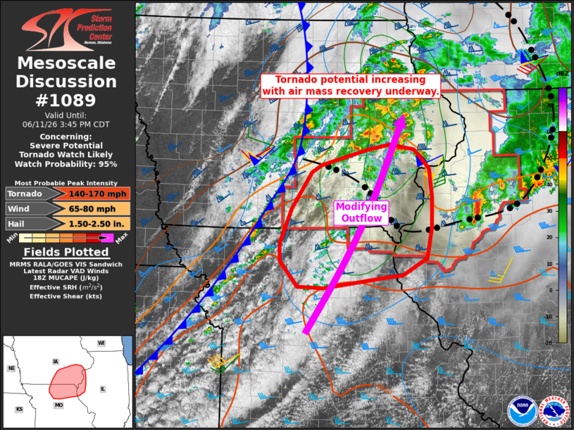
   Mesoscale Discussion 1089
   NWS Storm Prediction Center Norman OK
   0108 PM CDT Thu Jun 11 2026

   Areas affected...northeast Missouri...southern into eastern
   Iowa...far western Illinois

   Concerning...Severe potential...Tornado Watch likely 311...

   Valid 111808Z - 112045Z

   Probability of Watch Issuance...95 percent

   SUMMARY...The environment is becoming more favorable for severe
   storms with potential for tornadoes, and new/updated tornado watches
   are likely over parts of Iowa, Missouri, and Illinois.

   DISCUSSION...Recent satellite and surface observations indicate a
   modifying/retreating outflow boundary into south-central IA where
   winds are now out of the south and with low 70s F dewpoints.
   Meanwhile, the synoptic cold front continues to push rapidly east,
   along with the shortwave trough. This front is located from central
   IA into northwest MO as of 18Z with gusty southwest winds ahead of
   it. GPS PWAT is over 1.80" now into southern IA. Low-level shear is
   quite favorable for rotating storms near the retreating outflow,
   with 0-1 SRH over 200 m2/s2.

   Over the next few hours, storms are likely to develop near the cold
   front, and perhaps within the warm advection zone near the modifying
   outflow boundary. Supercells are expected initially with deep-layer
   shear near 55 kt and ample low-level SRH to support rightward cell
   propagation relative to the cold front orientation. A few strong
   tornadoes will be possible. Damaging winds also are likely as
   high-PWAT air mass supports ample downdraft material with any larger
   storm clusters or linear modes near the cold front.

   ..Jewell/Gleason.. 06/11/2026

   ...Please see www.spc.noaa.gov for graphic product...

   ATTN...WFO...ILX...LSX...DVN...DMX...EAX...

   LAT...LON   40359360 40869338 41379301 41469282 41699196 41769157
               41699111 41429084 41019079 40589079 40169089 39919133
               39899157 39739279 39759326 40119358 40359360

   MOST PROBABLE PEAK TORNADO INTENSITY...140-170 MPH
   MOST PROBABLE PEAK WIND GUST...65-80 MPH
   MOST PROBABLE PEAK HAIL SIZE...1.50-2.50 IN
|
|
|
Top/All Mesoscale Discussions/Forecast Products/Home |
|
Source link