| Mesoscale Discussion 1078 | |
| < Previous MD | |

|
|
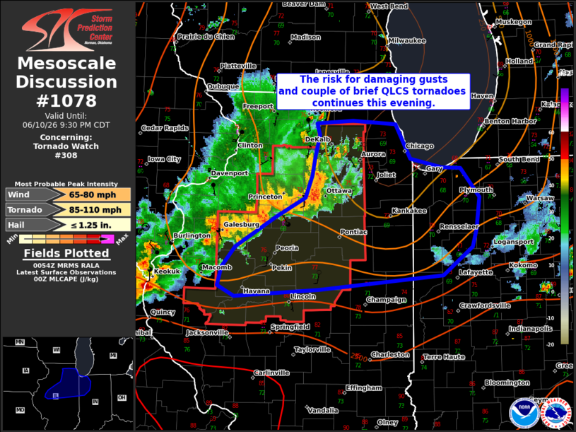
Mesoscale Discussion 1078 NWS Storm Prediction Center Norman OK 0755 PM CDT Wed Jun 10 2026 Areas affected...portions of northern Illinois and northwest Indiana Concerning...Tornado Watch 308... Valid 110055Z - 110230Z The severe weather threat for Tornado Watch 308 continues. SUMMARY...Severe/damaging gusts and a couple of QLCS tornadoes remain possible with a well-developed line of storms across northern IL. Conditions are being monitored for a downstream Severe Thunderstorm Watch. DISCUSSION...Across Tornado Watch 308, a severe squall line extended from northern IL southwestward toward the MS River. The northern most section of the line remains severe despite limited buoyancy from earlier convection. This section should approach the Chicago metro in the next hour with a risk for isolated damaging gusts and a brief QLCS tornado or two. Farther southwest, the environment is more unstable and this section of the line has started to show internal surges that could result in another bowing segment. Shear remains robust and a 40+ kt low-level jet should bolster the southern portions of the line this evening. The threat for severe gusts and QLCS tornado or two will continue across the Tornado Watch area in portions of central IL, and may extend into portions of northwestern IN tonight. A downstream Severe Thunderstorm Watch is being considered for northeastern IL into northwest IN. ..Lyons/Smith.. 06/11/2026 ...Please see www.spc.noaa.gov for graphic product... ATTN...WFO...IWX...IND...LOT...ILX...DVN... LAT...LON 41768756 41668708 41658681 41318652 40958657 40768664 40438707 40288892 40209017 40319042 40539037 40769016 41098956 41318912 41578903 41768899 42028892 42158896 42188841 42158778 41768756 MOST PROBABLE PEAK TORNADO INTENSITY...85-110 MPH MOST PROBABLE PEAK WIND GUST...65-80 MPH MOST PROBABLE PEAK HAIL SIZE...UP TO 1.25 IN |
|
|
Top/All Mesoscale Discussions/Forecast Products/Home |
|
Source link