| Mesoscale Discussion 1075 | |
| < Previous MD | |

|
|
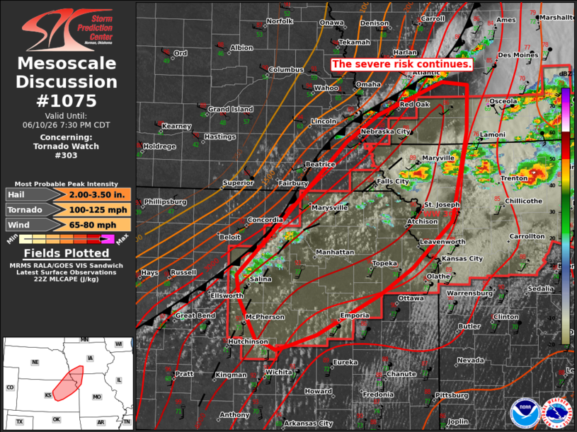
Mesoscale Discussion 1075 NWS Storm Prediction Center Norman OK 0557 PM CDT Wed Jun 10 2026 Areas affected...portions of southwest Iowa...southeast Nebraska...northeast Kansas and northwest Missouri Concerning...Tornado Watch 303... Valid 102257Z - 110030Z The severe weather threat for Tornado Watch 303 continues. SUMMARY...Large hail, damaging winds and a couple of tornadoes remain possible across Tornado Watch 303. New storm development and intensification is ongoing over northeast KS to the west of the ongoing supercells over northern MO. The environment remains very favorable for severe weather. DISCUSSION...West of the tornadic supercells ongoing over the eastern part of WW303, visible imagery showed deepening cumulus towers and incipient storms developing along the front and surface wind shift from northwest MO into IA/NE and northern KS. A very unstable air mass is in place ahead of the slow-moving cold front with 4000+ J/kg of MLCAPE which would support intense updrafts. Vertical shear is also supporting supercells, though linear forcing along the front and storm interactions could support a mixed convective mode. While new storm development has been gradual, likely owing to warmer mid-level temperatures, expectations are for additional storms to intensify over the next couple of hours. This matches well with recent CAM runs showing supercells and clusters evolving from the deepening CU over northeastern KS. Initially a risk for hail and damaging gusts is expected, but a 40+ kt low-level jet, depicted on area RAP soundings, will help increase low-level hodographs size later this evening. This would support the potential for a couple of tornadoes with any persistent supercells. ..Lyons.. 06/10/2026 ...Please see www.spc.noaa.gov for graphic product... ATTN...WFO...DMX...EAX...OAX...TOP...ICT... LAT...LON 38139747 38649774 38949780 39529719 40609606 40939554 41339451 41309409 40719412 39629437 39059500 38719551 38229652 38079696 38029717 38099732 38139747 MOST PROBABLE PEAK TORNADO INTENSITY...100-125 MPH MOST PROBABLE PEAK WIND GUST...65-80 MPH MOST PROBABLE PEAK HAIL SIZE...2.00-3.50 IN |
|
|
Top/All Mesoscale Discussions/Forecast Products/Home |
|
Source link