| Mesoscale Discussion 1068 | |
| < Previous MD | |

|
|
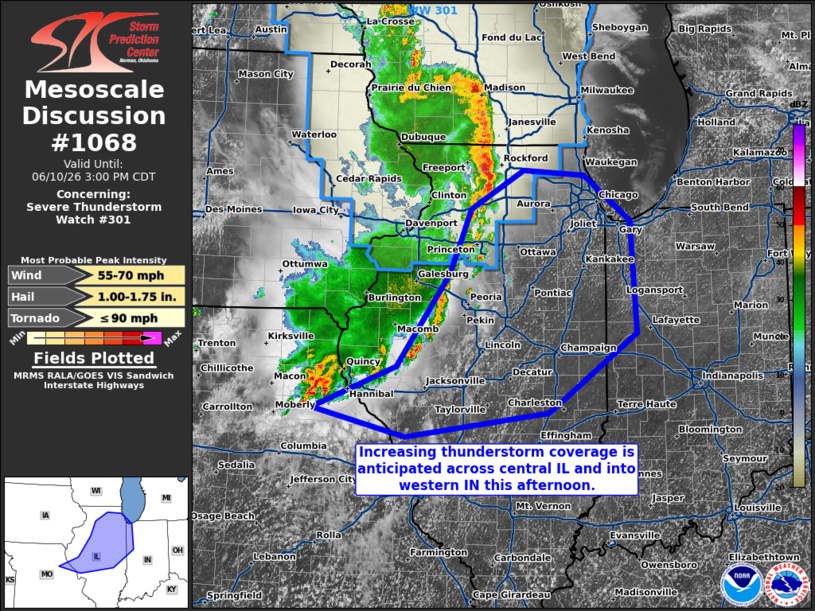
Mesoscale Discussion 1068 NWS Storm Prediction Center Norman OK 0206 PM CDT Wed Jun 10 2026 Areas affected...central Illinois and the vicinity Concerning...Severe Thunderstorm Watch 301... Valid 101906Z - 102000Z The severe weather threat for Severe Thunderstorm Watch 301 continues. SUMMARY...A line of thunderstorms is moving across WW301 and portions of northern/central IL. It may pose a threat for wind gusts and small hail during the afternoon. Watch issuance/extension may be needed to address this scenario. DISCUSSION...A large mesoscale convective system (MCS) continues to move east/northeastward across WW301 and portions of WI and IL. An expansive stratiform region is evident in regional radar imagery, and the cold pool is likely characterized by deficits around 10 F based on surface observations. A 64-kt gust was reported at 1740z in association with the bowing portion of the MCS currently moving northeastward into WI (northwest of the delineated region in this MCD). The southern portion of the MCS has been relatively less organized than its northern counterpart, probably owing to less deep ascent driven by less-line-orthogonal bulk shear. It is currently moving through the regional CAPE axis, characterized by MLCAPE around 2000-2500 J/kg, and the leading line has shown some recent uptick in convective organization (particularly in central IL). The 18z ILX sounding depicts a relatively uninhibited environment with around 30 kts of effective shear. This lends increasing confidence in some coverage of severe wind gusts and hail as the MCS propagates through central IL. Watch issuance/extension is being considered to address this scenario. ..Flournoy/Mosier.. 06/10/2026 ...Please see www.spc.noaa.gov for graphic product... ATTN...WFO...IWX...IND...LOT...ILX...LSX...DVN... LAT...LON 39169049 39489188 39969064 41038986 41768954 42208874 42148784 41628715 40358707 39448837 39169049 MOST PROBABLE PEAK TORNADO INTENSITY...UP TO 90 MPH MOST PROBABLE PEAK WIND GUST...55-70 MPH MOST PROBABLE PEAK HAIL SIZE...1.00-1.75 IN |
|
|
Top/All Mesoscale Discussions/Forecast Products/Home |
|
Source link