| Mesoscale Discussion 1059 | |
| < Previous MD Next MD > | |

|
|
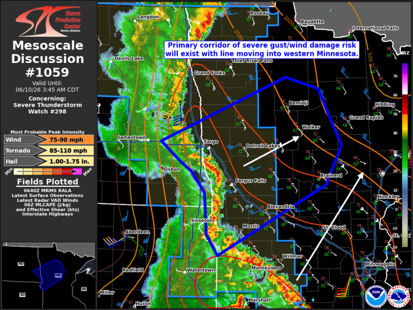
Mesoscale Discussion 1059 NWS Storm Prediction Center Norman OK 0142 AM CDT Wed Jun 10 2026 Areas affected...West-central into northern Minnesota Concerning...Severe Thunderstorm Watch 298... Valid 100642Z - 100845Z The severe weather threat for Severe Thunderstorm Watch 298 continues. SUMMARY...The threat for severe gusts/wind damage will increase into portions of northern Minnesota tonight. Isolated large hail and a QLCS tornado threat will also exist. A new watch is possible for north-central/northeast Minnesota within the next 1-2 hours. DISCUSSION...A small bowing segment is moving into west-central Minnesota. This portion of the broader convective line has been responsible for multiple severe gusts in northeastern South Dakota and southeastern North Dakota tonight. Given the favorable orientation of the line with respect to the deep-layer shear vector, this activity will likely be the focus for severe gusts/wind damage over the next few hours. While dewpoints do decrease farther northeast, some modest theta-e advection is expected to occur immediately ahead of this bowing structure. Steep mid-level lapse rates are still in place across the region so isolated large hail is possible even with a linear storm mode. A QLCS tornado also is possible. A new watch is possible for portions of north-central/northeast Minnesota within the next couple of hours. ..Wendt.. 06/10/2026 ...Please see www.spc.noaa.gov for graphic product... ATTN...WFO...DLH...MPX...FGF...ABR... LAT...LON 46269403 45189643 45509669 46149673 46479702 46619727 46929772 47919492 47739420 46869368 46269403 MOST PROBABLE PEAK TORNADO INTENSITY...85-110 MPH MOST PROBABLE PEAK WIND GUST...75-90 MPH MOST PROBABLE PEAK HAIL SIZE...1.00-1.75 IN |
|
|
Top/All Mesoscale Discussions/Forecast Products/Home |
|
Source link