| Mesoscale Discussion 1054 | |
| < Previous MD | |

|
|
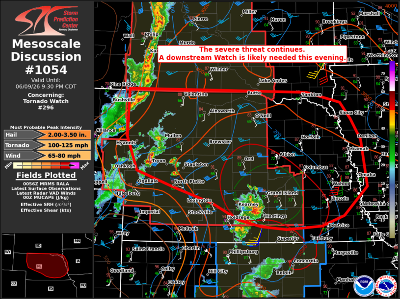
Mesoscale Discussion 1054 NWS Storm Prediction Center Norman OK 0759 PM CDT Tue Jun 09 2026 Areas affected...much of Nebraska into southeastern South Dakota and far western Iowa Concerning...Tornado Watch 296... Valid 100059Z - 100230Z The severe weather threat for Tornado Watch 296 continues. SUMMARY...Supercells and linear clusters remain capable of all hazards. A downstream watch for eastern NE and possibly into southeastern SD and/or western IA is likely this evening. DISCUSSION...Across Tornado Watch #296, several clusters of severe storms have organized over the past couple of hours. While intensification has been slow, the environment remains very unstable and will become increasingly sheared this evening. Storm mode remains mixed with supercells and linear clusters with a risk for severe wind gusts, large to very large hail and a couple of tornadoes. Additional storm development is expected across central NE tonight as ascent increases with the nocturnal low-level jet. Further intensification of the western supercells and line segments is expected, along with the linear the cluster along I-80 which has produced recent severe gusts to 80 mph. Tornado potential will be maximized with any discrete/semi-discrete supercells across central and northern NE near and after sunset. RAP sounding show a 50+ kt low-level jet increasing low-level hodograph size into the overnight hours. Given the continued risk and potential for storms to move east of the current watch, the severe risk continues and a downstream watch is likely needed this evening. ..Lyons/Smith.. 06/10/2026 ...Please see www.spc.noaa.gov for graphic product... ATTN...WFO...FSD...OAX...GID...LBF...UNR... LAT...LON 43030197 42989723 42779635 42439608 42019582 41089568 40529630 40329688 40269780 40319845 40459903 40789972 41090075 41400173 42070201 43030197 MOST PROBABLE PEAK TORNADO INTENSITY...100-125 MPH MOST PROBABLE PEAK WIND GUST...65-80 MPH MOST PROBABLE PEAK HAIL SIZE...2.00-3.50 IN |
|
|
Top/All Mesoscale Discussions/Forecast Products/Home |
|
Source link