| Mesoscale Discussion 1041 | |
| < Previous MD | |

|
|
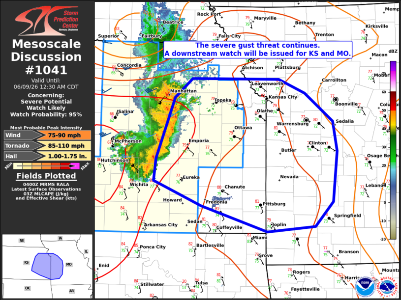
Mesoscale Discussion 1041 NWS Storm Prediction Center Norman OK 1102 PM CDT Mon Jun 08 2026 Areas affected...eastern Kansas and western Missouri Concerning...Severe potential...Watch likely Valid 090402Z - 090530Z Probability of Watch Issuance...95 percent SUMMARY...A bowing cluster will continue east/southeastward with a risk for severe gusts and a couple of tornadoes into the overnight hours. A new Watch will be issued downstream. DISCUSSION...An intense bowing complex over central KS with a history of significant wind damage is expected to continue east/southeastward this evening and overnight. Numerous reports of measured severe winds, damage, and observed radar velocities indicate this complex remains very strong. A large reservoir of buoyancy (MUCAPE 3000-4000 J/kg) remains in place over eastern KS, weakening into western MO. This should maintain the threat for damaging gusts with these strong storms for a few more hours tonight. Strong low-level shear could also support a couple of QLCS tornadoes. Current CAM trends eventually show weakening later tonight as the complex is forecast to move into weaker buoyancy and increasing nocturnal inhibition along the KS/MO border. However, the strength of the cold pool and radar observed rear inflow jet suggest this will take several hours. A threat for damaging gusts and QLCS tornadoes will likely continue for some time tonight. A Watch downstream from WW290 will be issued for portions of eastern KS and western MO in the next hour. ..Lyons/Gleason.. 06/09/2026 ...Please see www.spc.noaa.gov for graphic product... ATTN...WFO...SGF...EAX...TOP...ICT... LAT...LON 37109363 37019459 37429589 37829685 38179681 39139644 39449609 39429435 39219382 38759326 38299318 37489327 37109363 MOST PROBABLE PEAK TORNADO INTENSITY...85-110 MPH MOST PROBABLE PEAK WIND GUST...75-90 MPH MOST PROBABLE PEAK HAIL SIZE...1.00-1.75 IN |
|
|
Top/All Mesoscale Discussions/Forecast Products/Home |
|
Source link