|
|
| Mesoscale Discussion 1041 | |
| < Previous MD Next MD > | |

|
|
   Mesoscale Discussion 1041
   NWS Storm Prediction Center Norman OK
   1209 PM CDT Tue May 28 2024

   Areas affected...portions of far southern Kansas into western
   Oklahoma

   Concerning...Severe potential...Watch unlikely

   Valid 281709Z - 281915Z

   Probability of Watch Issuance...20 percent

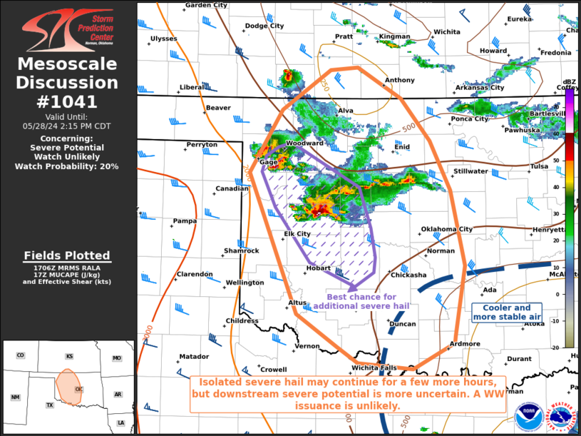
   SUMMARY...A couple instances of severe hail may accompany the
   stronger storms that manage to persist over the next few hours. The
   severe threat should remain isolated and a WW issuance is not
   expected.

   DISCUSSION...Multiple multicell clusters and supercells continue to
   progress across far southwestern KS into western OK, most of which
   have a history of severe hail, including a left-splitting storm in
   KS that has produced 2+ inch diameter hail. These storms continue to
   traverse an elevated buoyancy gradient, characterized by 8+ C/km
   mid-level lapse rates and 1000+ J/kg MUCAPE (most of which is above
   700 mb per latest RAP forecast soundings). Strong unidirectional
   speed shear above 700 mb is contributing to straight, elongated
   hodographs and around 40 kts of effective bulk shear. As such, any
   storms that persist within this CAPE/shear parameter space will have
   the potential to produce some hail (perhaps severe) over the next
   few hours, especially if any left-splitting supercells can
   materialize. However, there are some indications the ongoing storms
   may gradually weaken with time as they approach more stable air left
   behind by an earlier MCS. As such, any remaining severe threat may
   be brief and localized, so a WW issuance is not anticipated.

   ..Squitieri/Hart.. 05/28/2024

   ...Please see www.spc.noaa.gov for graphic product...

   ATTN...WFO...ICT...FWD...OUN...DDC...

   LAT...LON   36169988 36869943 37329877 37349838 37009779 36529738
               35969711 35119692 34319705 34249707 33959764 34019839
               34209866 34579922 36169988
|
|
|
Top/All Mesoscale Discussions/Forecast Products/Home |
|


