| Mesoscale Discussion 1007 | |
| < Previous MD | |

|
|
Mesoscale Discussion 1007
NWS Storm Prediction Center Norman OK
0442 PM CDT Sat Jun 06 2026
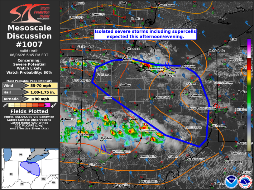
Areas affected...portions of northern and central Ohio
Concerning...Severe potential...Watch likely
Valid 062142Z - 062245Z
Probability of Watch Issuance...80 percent
SUMMARY...Strong to severe storms are expected to increase in
coverage this afternoon/evening. Hail and damaging gusts are
becoming more likely.
DISCUSSION...As of 2135 UTC, satellite and radar imagery over the
Great Lakes showed new thunderstorm development ongoing along an
east-west oriented surface front from western Lake Erie into
southern lower MI and northern IN. South of the boundary, upper 60s
to low 70s F surface dewpoints and strong heating are supporting
moderate instability with MLCAPE of 1500-2500 J/kg. With 40-50 kt of
deep-layer flow aloft overspreading the unstable air mass, organized
storms are expected. Already, supercells structures have been
observed and are likely to be the primary convective mode. Hail and
damaging winds are possible. Though surface flow is modest, some
veering and the potential for supercells suggests a tornado or two
is also possible.
Uncertainty remains on the east/southeastern extent of the severe
risk given ongoing convection over central/southern OH and the
impact of an earlier MCS. A remnant baroclinic zone may be the
primary focus for the strongest storms into central/northeastern OH
this evening. Given the expected increase in severe risk, a WW is
likely needed.
..Lyons/Gleason.. 06/06/2026
...Please see www.spc.noaa.gov for graphic product...
ATTN...WFO...PBZ...RLX...CLE...ILN...IWX...
LAT...LON 41268109 40648078 39778090 39618112 39898217 40858397
41158448 41508438 41678386 41728325 41578244 41568159
41408124 41268109
MOST PROBABLE PEAK TORNADO INTENSITY...UP TO 90 MPH
MOST PROBABLE PEAK WIND GUST...55-70 MPH
MOST PROBABLE PEAK HAIL SIZE...1.00-1.75 IN
|
|
|
Top/All Mesoscale Discussions/Forecast Products/Home |
|
Source link