| Mesoscale Discussion 999 | |
| < Previous MD Next MD > | |

|
|
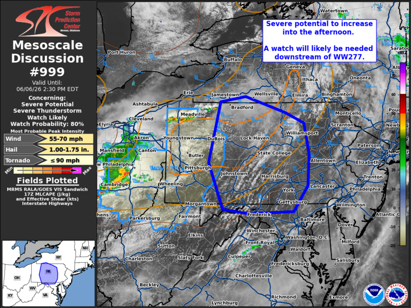
   Mesoscale Discussion 0999
   NWS Storm Prediction Center Norman OK
   1203 PM CDT Sat Jun 06 2026

   Areas affected...western/central Pennsylvania...northern/western
   Maryland

   Concerning...Severe potential...Severe Thunderstorm Watch likely

   Valid 061703Z - 061830Z

   Probability of Watch Issuance...80 percent

   SUMMARY...Thunderstorms with potential for damaging winds will
   increase in coverage through the afternoon.

   DISCUSSION...A cluster of severe thunderstorms continues eastward
   this afternoon across Ohio, producing gusts as high as 66 mph.
   Further to the northeast, additional thunderstorms are developing
   across portions of western PA into southwestern NY. Ahead of this
   activity, filtered heating has allowed temperatures to climb into
   the 80s with gradual eastward expansion of around 500 J/kg of
   MLCAPE. As further heating occurs, guidance suggests around
   1000-1500 J/kg MLCAPE will be in place through the afternoon with
   strengthening mid-level flow aloft overspreading the region and
   steepening low level lapse rates. This will promote further
   thunderstorm development and potential for downward mixing of higher
   momentum air and damaging wind potential. A watch will be needed to
   cover this potential soon.

   ..Thornton/Thompson.. 06/06/2026

   ...Please see www.spc.noaa.gov for graphic product...

   ATTN...WFO...PHI...BGM...BUF...CTP...LWX...PBZ...

   LAT...LON   42017891 42137816 41787699 41537643 40837628 40127633
               39547676 39537742 39497804 39607883 40647926 42017891

   MOST PROBABLE PEAK TORNADO INTENSITY...UP TO 90 MPH
   MOST PROBABLE PEAK WIND GUST...55-70 MPH
   MOST PROBABLE PEAK HAIL SIZE...1.00-1.75 IN
|
|
|
Top/All Mesoscale Discussions/Forecast Products/Home |
|
Source link