|
|
| Mesoscale Discussion 999 | |
| < Previous MD Next MD > | |

|
|
   Mesoscale Discussion 0999
   NWS Storm Prediction Center Norman OK
   0859 PM CDT Sun May 26 2024

   Areas affected...Far Southwest OH...Central/Eastern KY

   Concerning...Severe potential...Watch likely

   Valid 270159Z - 270300Z

   Probability of Watch Issuance...80 percent

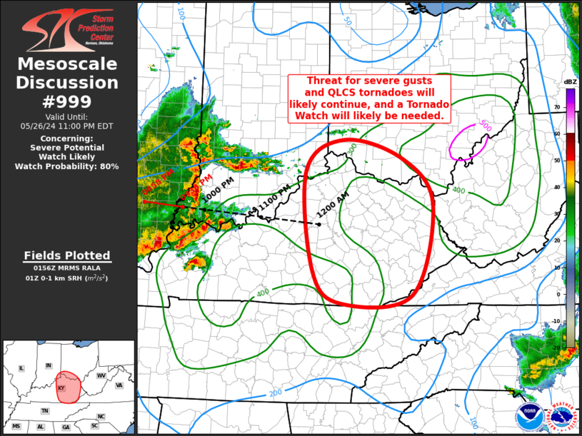
   SUMMARY...The threat for severe gust and QLCS circulations will
   likely continue into far southwest Ohio and central/eastern
   Kentucky, and a Tornado Watch will likely be needed across the
   region to address this potential.

   DISCUSSION...Well-organized convective line continues to move
   eastward across southwest IN, southern IL, and far southwest KY at
   around 50 to 55 kt. This storm motion takes the line to the edge of
   Tornado Watch 324 at 0330Z to 0400Z. The airmass over the region is
   only weakly buoyant right now, but increasing low to mid-level
   moisture ahead of the line should promote the development of modest
   buoyancy. This buoyancy will be aided by strong low-level shear.
   Recent 00Z BNA sounding sampled strong low-level flow veering with
   height, with 0-1 km storm-relative helicity over 330 m2/s2. Recent
   JKL VAD sampled this increasing low-level flow as well, with 0-1
   storm-relative helicity over 400 m2/s2.

   Given the favorable kinematics and organized character to the
   ongoing line, the expectation is that the threat for severe gusts
   and QLCS tornado circulations will continue into the region. A
   Tornado Watch will likely be needed across the region to address
   this potential.

   ..Mosier/Smith.. 05/27/2024

   ...Please see www.spc.noaa.gov for graphic product...

   ATTN...WFO...RLX...MRX...JKL...ILN...LMK...

   LAT...LON   38838527 39338447 39038327 38288260 36768306 36638453
               37188512 38838527
|
|
|
Top/All Mesoscale Discussions/Forecast Products/Home |
|


